CANTELLI DA VIGNOLLA, GIACOMO: MAP OF DALMATIA
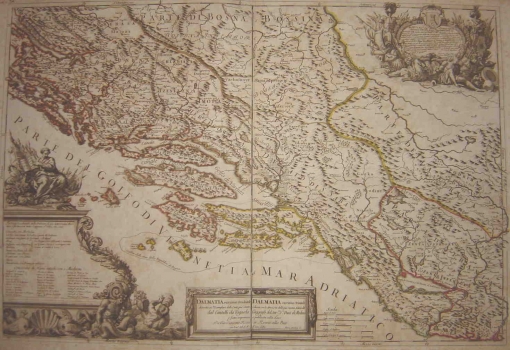
This map of Dalmatia by Giacoma Cantelli da Vignole issued in 1689 shows its medieval administrative division into counties within the boundaries as they looked like prior to the Turkish invasion. Coronelli displayed names of all Dalmatian medieval counties except for the counties of Lučka and Pset. So, he identified the names and boundaries of the counties of Nin (Nona), Sidraga (Sidgara), Biribir (Brebera), Primorska later known as Kliška (Paratalassia), Knin (Tnena), Livanjska (Chlebiana), Cetinska (Tzentzena) and Imotska (Imota). In the continental parts he identified the counties of Lika (Liczka), Gacka (Gouzecka ora Morlachia) and Krbavska (Caribasa). The map’s legend decisively states that that territory comprised 11 counties (Le costa occidentale della Dalmatia su’ gia detta Croatia Maritima è su’ divisa in undici zuppanie, o contee..) labelling each of them by name. In the map’s legend, for the counties of Nin, Sidraška and Bribirska he made the annotation that the area around Zrmanja is also known as Zadar district i.e. Contado di Zara. Considering scarcity of information relating to the position of boundaries and the size of the territory of Dalmatian counties, this map is an exceptionally interesting source for studying medieval administrative territorial organization of Dalmatia.
CANTELLI, DA VIGNOLA GIACOMO
