DE JODE, GERARD: MAP OF TIROL/ MAP OF CARNIOLA, KARST AND GORIZIA
Inventory number 91
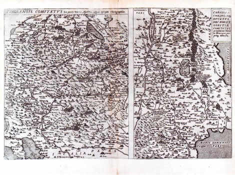
Original title: Tirolensis Comitatus seu partis Rhetia Alpes tris insignis descriptio Chorographica. Carniola Chaziolae Ducatus nec Non. et. Goritiae Comitatus / Wolfgang Lazio
Publishing year: 1593
Place of publishing and publisher: Antwerpen
Format: 28 x 34 cm, 22 x 34 cm
Technique: Copper engraving
It is a two-sheet chart of Tirol (or of Carniola, Karst and Gorizia) made by Wolfgang Lazio (1514-1565), a Viennese cartographer and University professor. The map was first published in his work "Typi chorographici prouvinciarum Austriae" in 1561. The Alps with major river systems and alpine lakes are depicted with great attention on the map of Tirol, and respectively the lake of Cernik on the map of Carniola. The Istrian peninsula is shown only partly and not in quite accurate way. Between Trieste and Senj is located the gulf of "Sinus Dalmaticus", while the topographic name "Dalmatia pars" marks the area to the north of Trieste. The region of Liburnia is put in the wrong place between the rivers Kupa and Dobra. Hirschvogel worked on map drawings of some antique authors as his sources. This can be concluded from the names of places indicated by Hirschvogel in forms used by Strabon and Pliny the Elder. This map went through many issues in the editions of Dutch publishers.
DE JODE, GERARD
GERARD DE JODE (1509-1591), a famous Dutch graphic artist, printer, publisher and cartographer. While he was preparing his world atlas, from 1555 de Jode was also issuing single maps: in 1560 he published Jacob Gastaldi's Great World Map, in 1563 the Map of Portugal, in 1564 Ortelius' World Map, and in 1569 a series of maps of German regions. Then Ortelius and de Jode had become tough business rivals. But, although he was 18 years older, de Jode was never that businesslike publisher as Ortelius. De Jode published in 1578 his atlas "Speculum Orbis Terrarum", only eight years after the "Theatrum Orbis Terrarum", Ortelius having obtained a monopoly for that period. The atlas was issued in 2 volumes. The first one contained 27 maps of various states and regions, while the 38 maps of the second volume entitled "Geographicum Germaniae Imperium Repraesentants" represents the German territories. Due to the predominance of Ortelius' issues, during de Jode's life, only two issues of his atlas were published (the second one in 1579). On his death, his son, CORNELIS DE JODE (1568-1600) completed his father's work and was published it in 1593. The new atlas comprising 83 maps was entitled "Speculum Orbis Terrae" . Now, de Jode's atlas is extremely rare (only 12 examples are known).