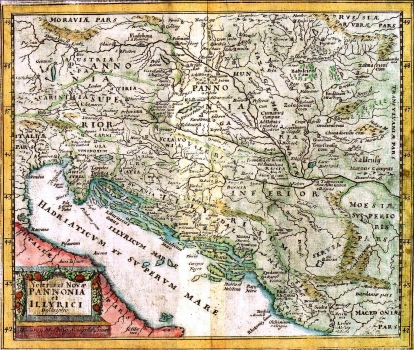
CLUVERIUS, PHILIPP: MAP OF PANNONIA AND ILLYRICUM
This is one of the revised and updated issues of Oretelius's historical map of the Roman provinces of Illyricum and Pannonia in the version of Philippe Cluverius. This example comes from a later edition issued by the Dutch publisher Hermann Mosting. The map shows Illyricum as it was during the Roman period with delineation of its administrative units as fixed during the restructuring of the Empire carried out by Diocletian in 297 BC. The map provides, along with ancient place names, a number of ethnic names of various Illyrian tribes that inhabited the area. The cartouche displaying the title is in the form of a stone monument embellished with a floral design. Below the cartouche, the names of the engraver and of the publisher are indicated.
CLUVERIUS, PHILIPP
