DE WITT, FREDERICK: MAP OF CARNIOLA, STYRIA AND THE COUNTY OF CELJE
Inventory number 254
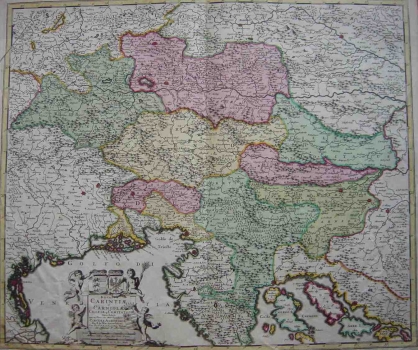
Original title: Ducatus Carinthiae et Carniolae, Cilleiae que Comitatus Nova Tabula qua et Pars est Meriditionalir circuli Austriaci…
Publishing year: 1711
Place of publishing and publisher: Amsterdam
Format: 49 x 50 cm
Technique: Coloured copper engraving
In 1706 Pierr Mortier became the owner of the firm de Witt and, in 1711, the firm passed in ownership of J. Covensa an C. Mortier who were the publishers of this map. The map was based on similar examples made by Mercator, Cantelli, Sanson and the Slovenian historian, researcher and natural scientist, Janez Vajkard Valvasor. The boundaries delineating the Upper, Central, Inner and Lower Carniola are marked, as well as those delineating the County of Celje, Venetian Istria and the Principality of Pazin. The area extending to the west featured on the map is quite vast so that much of Friuli is shown as well. The topography is shown with many faults drawn as shaded mole hills. The title is placed in the lower left corner of the map in a baroque cartouche adorned with cherubs and coats of arms of the lands shown.
DE WITT, FREDERICK
DE WITT, FREDERICK (1610-1698), a respected copper-plate engraver born in Palmanova, who lived and worked in Venice. He collaborated with the abbot Fortis on the maps from his travels around Dalmatia. He is believed to have been entrusted with the demanding work of engraving into copper plates sketches made by Fortis’s friend and companion Angelo Donati. This especially applies to the map from the second part of Fortis’s Viaggio in Dalmazia, published in 1774, I Contadi di Trau, Spalatro, e Macarska, il Primorie, e Narenta, coll'Isole aggiacenti. This map covers the region from Trogir to the estuary of the Neretva river and a part of Pelješac, with the islands Šolta, Brač, Hvar, Vis and Korčula. The geographical depictions are relatively precise, with somewhat less precise depictions of the terrain.