BUSSEMACHER, JOHANN: MAP OF DALMATIA, SLAVONIA, CROATIA AND BOSNIA
Inventory number 28
Author: BUSSEMACHER, JOHANN
Original title: Sclavonia, Croatia, Bosnia et Dalmatiae pars maior / Johann Bussemacher
Publishing year: 1592
Place of publishing and publisher: Köln: Matthias Quad
Format: 18,5x27 cm
Technique: Coloured copper engraving
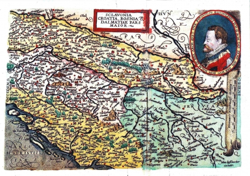
Bussemacher's map of Slavonia and Croatia was published in the atlas of Matthias Quad "Europae totius orbis terrarum" in 1592. It shows the territories of Slavonia, Croatia and partly Bosnia and Dalmatia roughly within their medieval borders i.e. before the invasion of Turks. The topography is shown with shaded molehills. In the upper right corner is a great oval portrait of Rudolph II. The title is across the upper central part of the map within a simple box. A mileage key is next the right margin of the map. The key is in common German miles (Milliaria Germanica communia).
BUSSEMACHER, JOHANN
JOHAN BUSSEMACHER (1580-1613), a German cartographer, engraver and editor. He worked in Köln. He participated in elaboration of some noted German and Dutch atlases.
