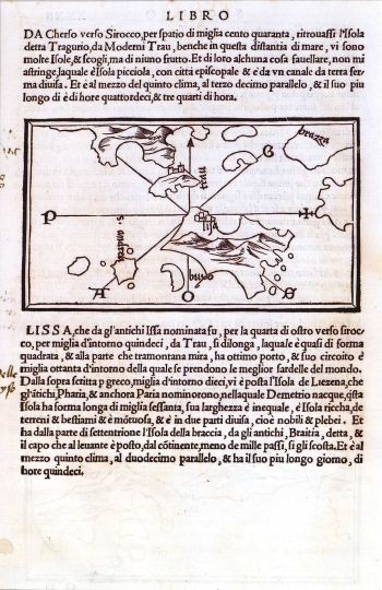
BORDONE, BENEDETTO: CHART OF THE ISLAND OF VIS
In the Isolario of Benedetto Bordone are included a few sea charts of the Croatian coast and islands, among them also a sea chart of Vis (Lissa). It is a rough drawn featuring basic outline of the island. Although this map was drawn after a similar map image published by Bartolomeo dalli Sonetti, the influence of medieval nautical charts (portolano charts) can be clearly seen through the schematic and fan-shaped modeling of island's contours. The map shows the indented eastern coast of the island with great detail. The most prominently featured is the Bay of Vis with the town of Vis. Beside the representation of the island the map includes a handsome wind rose that defines map's orientation. It shows four basic wind directions (cardinal winds): N=Tramontana, E=Levante (marked with a cross), S=Ostro or Mezzodi and W=Ponente, between which can be recognized different inter cardinal winds: NE=Greco, SE=Scirocco, Scilocco, SW=Garbino, Libeccio, NW=Maestro. Navigating this way in a northerly direction we reach Trogir, in a north westerly direction up to the island of Brač, in south westerly direction we reach the island of Svetac (St. Andrea), and in southerly direction the island of Biševo (Buso).
BORDONE, BENEDETTO
