CORONELLI, VINCENZO MARIA: DRINA AND BOJANA RIVER-SYSTEMS
Inventory number 64
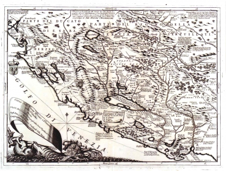
Original title: Corso delli fiumi Drino e Boiana nella Dalmatia. descrito Dal Padre Maestro Coronelli Cosmografo della Serenissima Republica di Venezia Dedicato Agli Eminente e Reuerendo Signori Cardinali della Sacra Congregatione de Propaganda Fide
Publishing year: 1688
Place of publishing and publisher: Venezia
Format: 44 x 60,5 cm
Technique: Copper engraving
The map shows the greater area of the rivers Drina and Bojana, that comprises a part of the Republic of Dubrovnik, the south part of the Venetian Dalmatia (Kotor), and the inland zone held by the Turks with Montenegro, Albania and Kosovo. It was published in the third issue of the atlas "Mari, golfi, isole…" edited by Coronelli. The map was produced during the Venetian-Turkish war for Morea (1683-1699). As it was created in a war atmosphere its contents were conditioned by it. About this witness a small map legend that reaches into the map image. Namely, next to each greater settlement a note is written down stating the number of orthodox, catholic and Moslem houses. Notes are often made about places of conflict with the Turks, especially about Venetian victories over Turkish forces. Within the Venetian owned territory administrative organization boundaries are indicated. The relief is only sporadically denoted by lines of shaded hills unable to feature real characteristics of the geographic area. A baroque cartouche in the lower left corner of the map contains the title. A mileage scale is in Italian miles.
CORONELLI, VINCENZO MARIA
VINCENZO MARIA CORONELLI (1650-1718). He was the most famous Italian cartographer from the period of the Venetian Republic. He established the society of geographers "Accademia degli Argonauta", one of the oldest in the world. In his cartographer's workshop in Venice he gathered a number of illustrators and cartographers. The Senate of Venice supported their work with large amounts of money, and Coronelli was the first cartographer who had a reputation as an official geographer of the Venetian Republic. His maps, a part of their strategic and economical importance, were also often used as powerful instruments of exaltation of Venice and its victories over theTurks. In delineation of boundaries Coronelli usually indicates the state of things as it was before the Turkish conquests, not recognizing Turkish possessions in Dalmatia. At the same time on all his maps he noted next to various places the names of the Venetian conquests during the Morean war. In the period nearing the end of the 17th century, his maps were used by all the state services of the Venetian Republic. Coronelli was the author of the best Venetian atlases: "Isolario dell'Atlante Veneto" issued in two volumes, also named "The Great Isolario". The other is "Mari, Golfi, Isle, Spiaggie, Porti, Citta…" issued in four volumes named "The Small Isolario" that comprises over 100 port and fortress plans including as well a number of map images of the Croatian coast.