CANTELLI DA VIGNOLLA, GIACOMO: MAP OF CROATIA AND THE COUNTY OF ZADAR
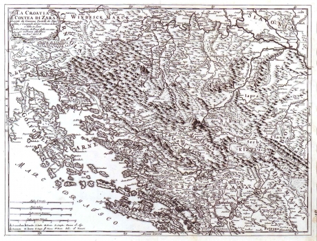
This Cantelli's map was issued in his atlas "Mercurio Geografico" published in Rome in 1692. The map of Croatia and of the county of Zadar is showing part of Croatia south of Sava with the Littoral up to the river Krka. The delineation of Croatian historical borders with Bosnia along the river Vrbas and the borders of Dalmatia in respect of Bosnia and Croatia are indicated. This map focuses on Zadar surrounding area, as central part of the Venetian Dalmatia, where at the time of production of this map some battles of the Morean war were fought between Venatian Republic and the Ottoman Empire. This war lasted until 1699. The topography is shown with shaded molehills, out of which the most prominently featured are "Monte Velebik" (Velebit), "Plessiuitza Mons" (Plješivica), "Visizbaba" (Visibaba), "Petra Klek" (Klek) and "Zrinksa Planina" (Zrinska gora). The representation of the network of rivers is accurate, the only exceptions being, the rivers Lika and Gacka which according to Cantelli flow in the sea near Karlobag. The title is shown in the upper left corner in a cartouche illustrated with vegetation vignettes. It is interesting that the mileage key besides in Italian, German and French is expressed in Croatian miles (Miglia di Croatia) too. Cantelli took this measure from the famous map of Croatia made by Stjepan Glavač dated from 1673.
CANTELLI, DA VIGNOLA GIACOMO
