CAMOCIO, GIOVANNI FRANCESCO: ISLAND OF HVAR
Inventory number 176
Author: CAMOCIO, GIOVANNI FRANCESCO
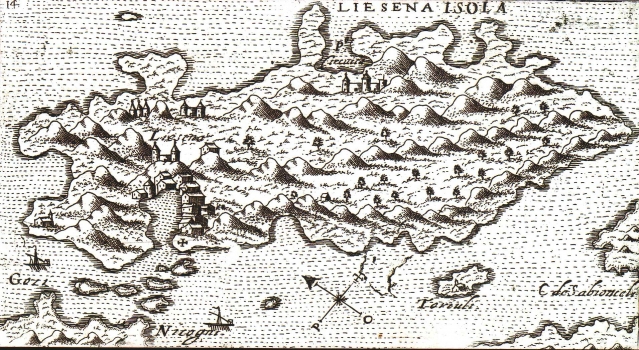
Original title: Liesena Isola / Francesco Camocio
Publishing year: 1572
Place of publishing and publisher: Venezia
Format: 10x18 cm
Technique: Copper engraving
This map was published in Camocio's book of islands "Isole Famose Porti…" in 1572. It was based on Bordone's sea chart of the island of Hvar of 1532. In the representation of the island, Camocio’s interest was focused on the town of Hvar, important Venetian port at the time. The bay of Hvar is largely oversized in proportion its importance. In the foreground, are the islands of Paklinski otoci and the island of Šćedro, the promontory of Lovišće jutting out from the peninsula of Pelješac and the northwest part of the island of Korčula are on the eastern side. In the northern part the town of Starigrad and its bay are highlighted with the symbol of palace. Geographical features are shown arbitrarily as roughly drawn shaded molehills.
CAMOCIO, GIOVANNI FRANCESCO
CAMOCIO, GIOVANNI FRANCESCO (Camocius, Camotio, Cametti, Gioan, Joan Francisco) a Venetian cartographer, publisher and merchant whose most productive period was between 1558 and 1575. He obtained his bookseller's and publisher's licence in Venice in 1552, marked Al segno della Pyramide. His copper-plate engraving workshop produced maps and vedute that as a publisher he was signing with apresso or apud G. F. Camocio cum privilegio. The most fertile period of his artistic production, between the 1550s and the 1570s, was also the peak of the isolarii (depictions of islands) period, especially in Italy. These are detailed, practical, perspective depictions of certain cities and ports, created predominantly in a large-scale copper-plate engraving technique. Unlike earlier portulan charts, these depictions of the maritime area and the inland of the islands were largely based on field work. Along with G. Rosaccio, G. Franco and S. Pinargenti, Camocio was the most significant representative of the tradition. His interest lay on the eastern Adriatic coast where he had his informants and topographers, so he created several maps of the Croatian lands. His most famous works are Lombardija Atlantic from 1560, which he created with Forlani, Dalmatia i Friuli from 1563, Isole Famose from 1563 and 1564, Grčka, Italija i Napulj from 1566, Venecija from 1571 and Europa, published in 1579. His copper plates were passed on to Donato Bertelli. Copper plates were, at the time, passed on, inherited, exchanged and traded, and the information they carried was also often exchanged among cartographers and publishers. His most famous maps of our (Croatian) territories are Novo dissegno della Dalmatia et Crovatia from 1566, Istra from 1569, and he also authored the isolario or atlas Isole famose, porti, fortezze e terre maritimme… from 1571 and 1574, comprising a large number of maps of the Croatian territories, although he did not author all of the maps contained within it. Almost twenty of his maps are depictions of the Croatian Littoral or port vedute, but he only signed some of them, which are most likely the ones he personally refined or updated. His maps of Dalmatia and Istria show that he had access to higher quality topographic templates or data only for some regions, such as Coppo’s map of Istria from 1525. He also published the works by local cartographers, Natalo Bonifaci and Martino Rota, from where he clearly sourced the cartographic information for his own works. He was obviously very skilled in selecting the information he would use, as he tried to correct some frequently repeated errors he had come accross.
