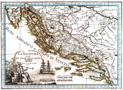
CASSINI, GIOVANNI MARIA: MAP OF DALMATIA
This Cassini's map of Dalmatia was published in the first volume of his atlas "Nuovo atlante geografico universale" of 1793. This really well laid out map, showing most of the Croatian lands, is interesting primarily for the delineation of political borders and place names illustrating the territorial disunity of the country divided between the neighbouring empires. The region extending between the rivers Sava and Una is denoted as Hungarian Croatia (Croazia Ungera), the area lying between the rivers Una and Vrbas as Turkish Croatia (Croazia Turca), today's Herzegovina as Turkish Dalmatia (Dalmazia Turca), while the part labelled as Venetian Dalmatia (Dalmazia Veneta) is comprised within the boundaries of the Venetian possessions as they were in 1730. Only Dubrovnik bears its proper name. The title of the map is in the lower left corner together with decorative designs showing a sailing vessel of the Venetian merchant marine type and a Turkish merchant. A mileage scale is in Italian and Roman miles.
CASSINI, GIOVANNI MARIA
