CORONELLI, VINCENZO MARIA: MAP OF ZADAR DISTRICT
Inventory number 185
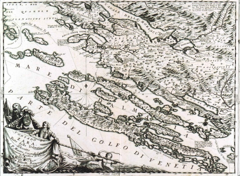
Original title: Contado di Zara. Parte della Dalmatia Descritto Dal Padre Maestro Coronelli Cosmografo della Serenissima Republica di venetia Dedicato a Monsignor Illustrissimo e Reverendissimo Maffei Farsetti, Pronotario Apostolico, et Auditore della Signatura in Venetia 1688. con Privilegio dell Eccellentissimo Senato
Publishing year: 1696
Place of publishing and publisher: Venezia
Format: 46 x 60 cm
Technique: Copper engraving
Coronelli's map of Zadar district (Contado) was first published in his famous atlas “Isolario dell’ Atlante Veneto”. The map shows parts of Dalmatia that extend between the islands of Pag and Murter, as well as the area of Ravni kotari and a part of Lika within its inland zone. The contours are shown of the district of Zadar that, at the time of Venetian rule, was one of the administrative-territorial units Dalmatia was divided into. The author denoted the town of Zadar by its ground plan to highlight its importance as administrative centre of Dalmatia at the time. Next to some place names together with that-time name the ancient names are given. The map also includes annotations on some islands and coastal places shown. So, the note set in near the island of Vrgada says that the same was awarded to Francesco Damiani on 19.9.1682, while for Žirje is stated that this island was famous for its abundance of corals and pilchard. The title of the map is in its lower left corner on a great flag toped by the Venetian Lion and the arms of the town Zadar. The scale is expressed in Italian miles (Miglia Italiane).
CORONELLI, VINCENZO MARIA
VINCENZO MARIA CORONELLI (1650-1718). He was the most famous Italian cartographer from the period of the Venetian Republic. He established the society of geographers "Accademia degli Argonauta", one of the oldest in the world. In his cartographer's workshop in Venice he gathered a number of illustrators and cartographers. The Senate of Venice supported their work with large amounts of money, and Coronelli was the first cartographer who had a reputation as an official geographer of the Venetian Republic. His maps, a part of their strategic and economical importance, were also often used as powerful instruments of exaltation of Venice and its victories over theTurks. In delineation of boundaries Coronelli usually indicates the state of things as it was before the Turkish conquests, not recognizing Turkish possessions in Dalmatia. At the same time on all his maps he noted next to various places the names of the Venetian conquests during the Morean war. In the period nearing the end of the 17th century, his maps were used by all the state services of the Venetian Republic. Coronelli was the author of the best Venetian atlases: "Isolario dell'Atlante Veneto" issued in two volumes, also named "The Great Isolario". The other is "Mari, Golfi, Isle, Spiaggie, Porti, Citta…" issued in four volumes named "The Small Isolario" that comprises over 100 port and fortress plans including as well a number of map images of the Croatian coast.