CORONELLI, VINCENZO MARIA: MAP OF THE BAY OF CATTARO
Inventory number 195
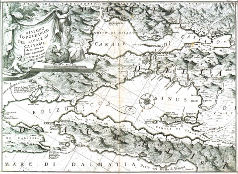
Original title: Disegno topografico del Canale di Cattaro descritto dal Padre Coronelli in Venezia l’ anno MDCLXXXVIII
Publishing year: 1969
Place of publishing and publisher: Venezia
Format: 43 x 60,5 cm
Technique: Copper engraving
Coronelli's Map of The Bay of Kotor (Boka Kotorska) dated 1688 appeared in his atlas “Isolario dell’ Atlante Veneto” which was published in 1696. The map shows the bay while being in Venetian possession with the exception of Vitaljina and Prevlaka that formed part of the Republic of Dubrovnik. The Venetians captured the town of Kotor in 1520, and by 1540 they extended their power on the entire southeast part of the golf. They conquered the north west part of Boka during the war 1683-1699. The annotation on the conquest of Herceg-Novi happened in 1687 is also included. The title of the map is in its upper left corner contained in a banner embellished with illustrations drawn in a pastoral style. The map’s scale is expressed in foots (scala de passa).
CORONELLI, VINCENZO MARIA
VINCENZO MARIA CORONELLI (1650-1718). He was the most famous Italian cartographer from the period of the Venetian Republic. He established the society of geographers "Accademia degli Argonauta", one of the oldest in the world. In his cartographer's workshop in Venice he gathered a number of illustrators and cartographers. The Senate of Venice supported their work with large amounts of money, and Coronelli was the first cartographer who had a reputation as an official geographer of the Venetian Republic. His maps, a part of their strategic and economical importance, were also often used as powerful instruments of exaltation of Venice and its victories over theTurks. In delineation of boundaries Coronelli usually indicates the state of things as it was before the Turkish conquests, not recognizing Turkish possessions in Dalmatia. At the same time on all his maps he noted next to various places the names of the Venetian conquests during the Morean war. In the period nearing the end of the 17th century, his maps were used by all the state services of the Venetian Republic. Coronelli was the author of the best Venetian atlases: "Isolario dell'Atlante Veneto" issued in two volumes, also named "The Great Isolario". The other is "Mari, Golfi, Isle, Spiaggie, Porti, Citta…" issued in four volumes named "The Small Isolario" that comprises over 100 port and fortress plans including as well a number of map images of the Croatian coast.