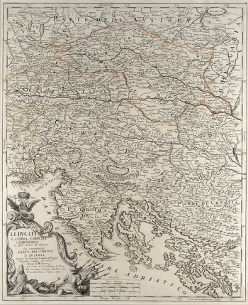
CANTELLI DA VIGNOLLA, GIACOMO: MAP OF STYRIA, CARNIOLA AND CARINTHIA
Cantelli’s map of Styria, Carniola and Carinthia shows all of Istria, upper part of the Adriatic Sea, the western part of Croatia and the northern part of Dalmatia. It was included in Cantelli’s atlas “Mercurio Geografico”, published by the Roman map publisher and printer Giacomo Rossi in 1690. Although other maps by Cantelli are noted for their accurate representation of the Croatian lands as they were in the 17th century that is not the case with this one. The coastal outlines and island contours show considerable deformations. The northern part of the island of Cres with the settlement of Porozina (Perosina) is shown as an island. The island of Pag (Pago) is hardly recognizable, as well as the north-Dalmatian islands Pašman (Pasman) and Dugi otok (Isola Grossa). Only the area surrounding the lake Cerniško jezero is presented as being covered in forest identified by a symbol of tree. The tithe of the map is in the lower left corner set within an elaborate baroque cartouche decorated with figures of fastened Turkish soldiers as well as numerous arms and banners as a lasting reminder of that of the Venetian-Turkish wars in which the Turks were driven back by the Venetians from a part of the Dalmatian hinterland.
CANTELLI, DA VIGNOLA GIACOMO
