CANTELLI DA VIGNOLLA, GIACOMO: MAP OF SLAVONIA
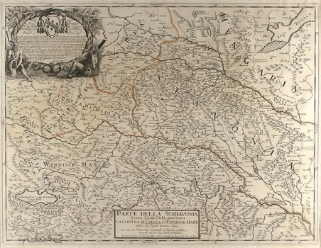
The map of Slavonia by Cantelli from his atlas “Mercurio Geografico” issued in Rome in 1690 by the publisher and printer Giacomo Rossi. The map shows parts of the medieval Slavonia, Croatia south of the river Sava, the district of Celje comprised within Styria (Contea di Cillea), a portion of Styria and the Windish Mark laying within Carniola. This map was produced immediately after the liberation of Slavonia from Turkish occupation. Cantelli’s representation of Croatia and Slavonia is based on the noted map of Croatia of Stjepan Glavač drawn in 1673. The topography is represented with shaded molehills. Forested lands within the areas of Slavonia and Windish Mark are depicted as groups of individually drawn trees. Marshy areas around Čazma (Tsazma) and Lonjsko polje (Tsigatz o Lonsko Polie) are designated as lakes. It is interesting that within the area of present-day Zagreb two that-time settlements are identified as Zagrabia or Agram, Vlaška Street is designated as parish of S. Petrus, (Sv. Duh) and the town village of Trnje (Ternie), and the villages of Banovići (Bancosi) and Ilijašići (Ilasitsu) every trace of which disappeared during the 18th century are identified in the area of present-day town ward of Trešnjevka. In the area of Western Slavonia he indicated, after the model of the map by Glavač, the area of Greek-catholic Valach colonization (Vallachi Pop. di Rito Greco). The title of the map is along the lower margin placed within a simple box cartouche.
CANTELLI, DA VIGNOLA GIACOMO
