CAMOCIO, GIOVANNI FRANCESCO: VIEW OF THE DISTRICT OF ZADAR
Inventory number 273
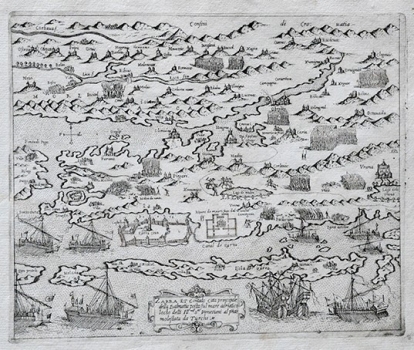
Original title: Zara et Contado citta principale della Dalmatia posta sul mare adriatico locho delli Ill[ustrissi]mi S[igno]ri Venetiani al p[rese]nte molestada da Turchi
Publishing year: 1571
Place of publishing and publisher: Venezia
Format: 16,5 x 21 cm
Technique: Copper engraving
This view of Zadar inland zone was made by the Croatian cartographer Martin Rota Kolunić for the isolario entitled “Isole famose porti, fortezze, e terre maritime sottoposte della serenissima Signoria di Venetia, ad altri Principi Christiani, et al signor Turco, nuoamete poste in luce” published by Giovanni Francesco Camoscio in 1571. Together with the view of the surroundings of Šibenik, this is the most noted and most important Kolunić’s map. It shows Zadar with its surrounding area as it was during the Venetian-Turkish war. The boundaries of the area in the inland zone of Šibenik occupied by the Turks are delineated by dotted line. The conflicts taking place both in the continent and on the sea are shown. After the issuance of the map of Zadar and Šibenik with their surroundings by Mateo Pagano appeared in 1530, this is one of the rare maps of the inland zone of Zadar much part of which at that time was under Turkish rule. As at that time, direct topographic surveys of that area were not possible, Kolunić, also a native of Šibenik, made this map out of his own memory of this area he knew exceptionally well. The map went through a series of editions and revisions both in later issues of isolarios and in a number of atlases published during the 16th and 17th centuries.
CAMOCIO, GIOVANNI FRANCESCO
CAMOCIO, GIOVANNI FRANCESCO (Camocius, Camotio, Cametti, Gioan, Joan Francisco) a Venetian cartographer, publisher and merchant whose most productive period was between 1558 and 1575. He obtained his bookseller's and publisher's licence in Venice in 1552, marked Al segno della Pyramide. His copper-plate engraving workshop produced maps and vedute that as a publisher he was signing with apresso or apud G. F. Camocio cum privilegio. The most fertile period of his artistic production, between the 1550s and the 1570s, was also the peak of the isolarii (depictions of islands) period, especially in Italy. These are detailed, practical, perspective depictions of certain cities and ports, created predominantly in a large-scale copper-plate engraving technique. Unlike earlier portulan charts, these depictions of the maritime area and the inland of the islands were largely based on field work. Along with G. Rosaccio, G. Franco and S. Pinargenti, Camocio was the most significant representative of the tradition. His interest lay on the eastern Adriatic coast where he had his informants and topographers, so he created several maps of the Croatian lands. His most famous works are Lombardija Atlantic from 1560, which he created with Forlani, Dalmatia i Friuli from 1563, Isole Famose from 1563 and 1564, Grčka, Italija i Napulj from 1566, Venecija from 1571 and Europa, published in 1579. His copper plates were passed on to Donato Bertelli. Copper plates were, at the time, passed on, inherited, exchanged and traded, and the information they carried was also often exchanged among cartographers and publishers. His most famous maps of our (Croatian) territories are Novo dissegno della Dalmatia et Crovatia from 1566, Istra from 1569, and he also authored the isolario or atlas Isole famose, porti, fortezze e terre maritimme… from 1571 and 1574, comprising a large number of maps of the Croatian territories, although he did not author all of the maps contained within it. Almost twenty of his maps are depictions of the Croatian Littoral or port vedute, but he only signed some of them, which are most likely the ones he personally refined or updated. His maps of Dalmatia and Istria show that he had access to higher quality topographic templates or data only for some regions, such as Coppo’s map of Istria from 1525. He also published the works by local cartographers, Natalo Bonifaci and Martino Rota, from where he clearly sourced the cartographic information for his own works. He was obviously very skilled in selecting the information he would use, as he tried to correct some frequently repeated errors he had come accross.