CORONELLI, VINCENZO MARIA: MAP OF THE ISLAND OF KRK
Inventory number 302
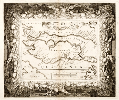
Original title: Isola di Veglia
Publishing year: 1690
Place of publishing and publisher: Venezia
Format: 26 x 33 cm
Technique: Copper engraving
This Coronelli’s map of the island of Krk was published in his small isolario entitled «Mari, golfi, isole, spiaggie..», issued in Venice around 1690. This map shows the entire island of Krk (Isola di Veglia), the Istrian peninsula, the area in the foot of the mountain-range of Velebit (Morlaca) with Velebit channel (Canale de Montagna), the island Prvić (Preuichio), the island Grgur (S. Greg) and parts of the islands of Cres (Isola da Cherzo) and Rab (Isola Arbe). In the coastal profiles of the island of Krk especially emphasized are the bay of Soline, the bay of Omišalj and Puntarska draga with the towns of Krk, Putat and the islet of Košljun. Apart from place names the map gives a lot of names of bays and caps, and in that respect represent an interesting historic document. The map’s title appears along its inner margin edge written on a flag waiving in the wind. A mileage scale is expressed in Venetian miles (Miglia di Venezia).
CORONELLI, VINCENZO MARIA
VINCENZO MARIA CORONELLI (1650-1718). He was the most famous Italian cartographer from the period of the Venetian Republic. He established the society of geographers "Accademia degli Argonauta", one of the oldest in the world. In his cartographer's workshop in Venice he gathered a number of illustrators and cartographers. The Senate of Venice supported their work with large amounts of money, and Coronelli was the first cartographer who had a reputation as an official geographer of the Venetian Republic. His maps, a part of their strategic and economical importance, were also often used as powerful instruments of exaltation of Venice and its victories over theTurks. In delineation of boundaries Coronelli usually indicates the state of things as it was before the Turkish conquests, not recognizing Turkish possessions in Dalmatia. At the same time on all his maps he noted next to various places the names of the Venetian conquests during the Morean war. In the period nearing the end of the 17th century, his maps were used by all the state services of the Venetian Republic. Coronelli was the author of the best Venetian atlases: "Isolario dell'Atlante Veneto" issued in two volumes, also named "The Great Isolario". The other is "Mari, Golfi, Isle, Spiaggie, Porti, Citta…" issued in four volumes named "The Small Isolario" that comprises over 100 port and fortress plans including as well a number of map images of the Croatian coast.