CORONELLI, VINCENZO MARIA: VIEW OF OMIŠ
Inventory number 303
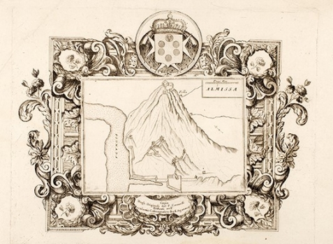
Original title: Almissa
Publishing year: 1690
Place of publishing and publisher: Venezia
Format: 26 x 33 cm
Technique: Copper engraving
This Coronelli’s view shows the complex fortification system of the town of Omiš. The old Croatian town of Omiš is situated at the foot of abrupt slopes of the mount Dinara, bounded by the river Cetina on the North East, and on the South and South East by the sea. It developed as a suburb (burgum, suburbiam) of the fortress of Omiš (castrum) built on the hill high above it. As it was permanently menaced from the continent and from the sea and the fortress of Starigrad (Fortice) and the auxiliary fortress of Viseć in the canyon of the river Cetina, ware not able to provide efficient protection to the town, Omiš was encircled by the walls as early as the Middle Ages and that walls were reinforced by special jutting structures on the eastern, mainland side, and on the northern side by the fort of Peovica (Mirabella). Thanks to their excellent command of the sea the seamen (pirates) of Omiš controlled the navigation along the Adriatic Sea from the 13th until the early years of the 15th century, principally bringing into peril Venetian ships and their possession in Dalmatia, as well as the ships of the Kingdom of Naples. From 1444, Omiš forms part of the Venetian Republic. In Coronelli’s times Omiš was one of the Venetian Dalmatian fortresses of major importance, and that is the reason why the plan of its fortifications found place in his small isolario «Mari, golfi, isole, spiaggie..», issued in Venice around 1690.
CORONELLI, VINCENZO MARIA
VINCENZO MARIA CORONELLI (1650-1718). He was the most famous Italian cartographer from the period of the Venetian Republic. He established the society of geographers "Accademia degli Argonauta", one of the oldest in the world. In his cartographer's workshop in Venice he gathered a number of illustrators and cartographers. The Senate of Venice supported their work with large amounts of money, and Coronelli was the first cartographer who had a reputation as an official geographer of the Venetian Republic. His maps, a part of their strategic and economical importance, were also often used as powerful instruments of exaltation of Venice and its victories over theTurks. In delineation of boundaries Coronelli usually indicates the state of things as it was before the Turkish conquests, not recognizing Turkish possessions in Dalmatia. At the same time on all his maps he noted next to various places the names of the Venetian conquests during the Morean war. In the period nearing the end of the 17th century, his maps were used by all the state services of the Venetian Republic. Coronelli was the author of the best Venetian atlases: "Isolario dell'Atlante Veneto" issued in two volumes, also named "The Great Isolario". The other is "Mari, Golfi, Isle, Spiaggie, Porti, Citta…" issued in four volumes named "The Small Isolario" that comprises over 100 port and fortress plans including as well a number of map images of the Croatian coast.