CORONELLI, VINCENZO MARIA: PLAN OF THE FORTIFICATIONS OF ŠIBENIK
Inventory number 304
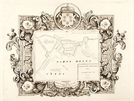
Original title: Castello vecchio di Sebenico nella Dalmatia
Publishing year: 1690
Place of publishing and publisher: Venezia
Format: 26 x 33 cm
Technique: Copper engraving
The old Croatian town of Šibenik whose name was first documented in 1066 developed around former Illyrian citadel located on the site of today’s fortress of St. Anna, where upon the arrival of the Croatian tribes in 9th century these new inhabitants organized their stronghold Šibenik. The fortress situated on the top of a 70-meter rock overhanging the river Krka was and continued to be an insurmountable obstacle to many invaders during the stormy centuries to come. At the beginning of the 15th century Šibenik fell under the rule of the Venetian Republic, becoming one of the key fortresses in the defence line of Dalmatia intended to protect it from the Turks. Due to permanent danger of Turkish attacks, in only two months in 1646 besides the already existent old fortress two more fortresses were built i.e. the fortresses of St. John and Šubićevac. The Turkish attacks on the town will stay intensive for the next two hundred years, and the most dangerous one occurred during the Candian war in 1647 when the troops of Tekelia pasha suffered a heavy defeat under the ramparts of Šibenik. Due to its importance in the Venetian-Turkish wars, Coronelli inserted its view in his isolario «Mari, golfi, isole, spiaggie..», dedicating special attention precisely to this town, making several plans of the fortifications of Šibenik. This plan shows the old part of the fortresses of Šibenik (Castello vecchio).
CORONELLI, VINCENZO MARIA
VINCENZO MARIA CORONELLI (1650-1718). He was the most famous Italian cartographer from the period of the Venetian Republic. He established the society of geographers "Accademia degli Argonauta", one of the oldest in the world. In his cartographer's workshop in Venice he gathered a number of illustrators and cartographers. The Senate of Venice supported their work with large amounts of money, and Coronelli was the first cartographer who had a reputation as an official geographer of the Venetian Republic. His maps, a part of their strategic and economical importance, were also often used as powerful instruments of exaltation of Venice and its victories over theTurks. In delineation of boundaries Coronelli usually indicates the state of things as it was before the Turkish conquests, not recognizing Turkish possessions in Dalmatia. At the same time on all his maps he noted next to various places the names of the Venetian conquests during the Morean war. In the period nearing the end of the 17th century, his maps were used by all the state services of the Venetian Republic. Coronelli was the author of the best Venetian atlases: "Isolario dell'Atlante Veneto" issued in two volumes, also named "The Great Isolario". The other is "Mari, Golfi, Isle, Spiaggie, Porti, Citta…" issued in four volumes named "The Small Isolario" that comprises over 100 port and fortress plans including as well a number of map images of the Croatian coast.