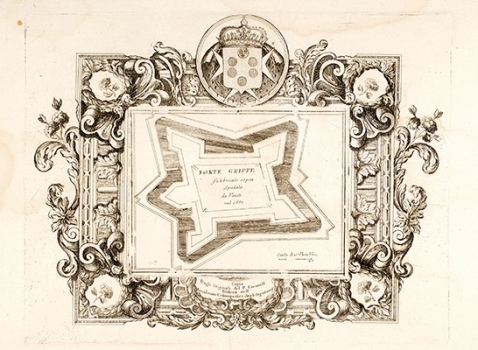
CORONELLI, VINCENZO MARIA: PLAN OF THE FORT OF GRIPE IN SPLIT
Inventory number 305
Author: CORONELLI, VINCENZO MARIA
Original title: Forte Grippe fabbricato sopra Split da Veneti nul 1657.
Publishing year: 1690
Place of publishing and publisher: Venezia
Format: 26 x 33 cm
Technique: Copper engraving
This Coronelli’s plan shows the fort of Gripe, one of the best-known fortifications of Split. The fort of Gripe is a Baroque Venetian fort built in the 17th century. The fort of Gripe was constructed under the supervision of Camillo Gonzaga who also achieved the construction of the fort of Bačvice. As early as in 1657 both forts were able to be used in the defence of the town and hold off Turkish assaults. The fort of Gripe was finally achieved in 1660. It is interesting to note that Gripe had never got its North West bastion, shown on this idealized plan by Vincenzo Maria Coronelli. This Coronelli’s plan of the fort of Gripe was inserted in his small isolario «Mari, golfi, isole, spiaggie..», issued in Venice around 1690.
CORONELLI, VINCENZO MARIA
VINCENZO MARIA CORONELLI (1650-1718). He was the most famous Italian cartographer from the period of the Venetian Republic. He established the society of geographers "Accademia degli Argonauta", one of the oldest in the world. In his cartographer's workshop in Venice he gathered a number of illustrators and cartographers. The Senate of Venice supported their work with large amounts of money, and Coronelli was the first cartographer who had a reputation as an official geographer of the Venetian Republic. His maps, a part of their strategic and economical importance, were also often used as powerful instruments of exaltation of Venice and its victories over theTurks. In delineation of boundaries Coronelli usually indicates the state of things as it was before the Turkish conquests, not recognizing Turkish possessions in Dalmatia. At the same time on all his maps he noted next to various places the names of the Venetian conquests during the Morean war. In the period nearing the end of the 17th century, his maps were used by all the state services of the Venetian Republic. Coronelli was the author of the best Venetian atlases: "Isolario dell'Atlante Veneto" issued in two volumes, also named "The Great Isolario". The other is "Mari, Golfi, Isle, Spiaggie, Porti, Citta…" issued in four volumes named "The Small Isolario" that comprises over 100 port and fortress plans including as well a number of map images of the Croatian coast.
