CORONELLI, VINCENZO MARIA: MAP OF THE ISLAND OF VIS
Inventory number 359
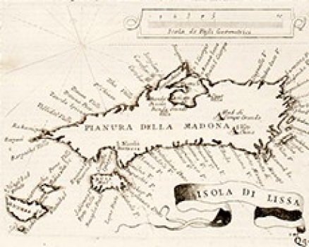
Original title: Isola di Lissa
Publishing year: 1696
Place of publishing and publisher: Venezia
Format: 13 x 17 cm
Technique: Copper engraving
This Coronelli’s representation of the island of Vis was included into his great isolario /book of islands/ titled «Isolario dell Atlante Veneto» that comprises a series of maps and sea charts relating to the Croatian coastal zone and islands. From the way of representing Vis, it is evident that this map was modelled upon some earlier Venetian porotlano chart. Its function as navigational aid is confirmed by the features it includes i.e. the map focuses on the coastal geography, providing names of a number of coves and capes of the island leaving the island’s interior almost blank. It is clearly visible how the Bay of Komiža and the harbour of Vis are configured. Off the coast of Vis we see the island of Biševo (Busi) and to the west of it the islets of Brusnik and Svetac (St. Andrea).
CORONELLI, VINCENZO MARIA
VINCENZO MARIA CORONELLI (1650-1718). He was the most famous Italian cartographer from the period of the Venetian Republic. He established the society of geographers "Accademia degli Argonauta", one of the oldest in the world. In his cartographer's workshop in Venice he gathered a number of illustrators and cartographers. The Senate of Venice supported their work with large amounts of money, and Coronelli was the first cartographer who had a reputation as an official geographer of the Venetian Republic. His maps, a part of their strategic and economical importance, were also often used as powerful instruments of exaltation of Venice and its victories over theTurks. In delineation of boundaries Coronelli usually indicates the state of things as it was before the Turkish conquests, not recognizing Turkish possessions in Dalmatia. At the same time on all his maps he noted next to various places the names of the Venetian conquests during the Morean war. In the period nearing the end of the 17th century, his maps were used by all the state services of the Venetian Republic. Coronelli was the author of the best Venetian atlases: "Isolario dell'Atlante Veneto" issued in two volumes, also named "The Great Isolario". The other is "Mari, Golfi, Isle, Spiaggie, Porti, Citta…" issued in four volumes named "The Small Isolario" that comprises over 100 port and fortress plans including as well a number of map images of the Croatian coast.