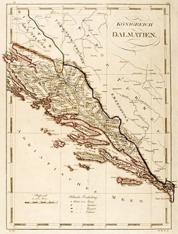
UNKNOWN: MAP OF DALMATIA
Inventory number 379
Author: ANONIM / ANONYM / NOT KNOWN
Original title: Königreich Dalmatien
Publishing year: 1840
Place of publishing and publisher: Wien (?)
Format: 29 x 39,5 cm
Technique: Steel engraving
The map shows the coast of the Adriatic Sea from Nin, i.e. the island of Pag to Ulcinj, during the Austrian rule, which declares that area to the Kingdom of Dalmatia, which includes also the Republic of Dubrovnik. Given the existence of the Military Border, and that part of Croatia and Bosnia and Herzegovina are still parts of the Ottoman Empire, it is to be assumed that the map was created before the 1870s. Relief is presented fairly credible with shading and special importance is given to existing traffic communication.
ANONIM / ANONYM / NOT KNOWN
