CANTELLI DA VIGNOLLA, GIACOMO: MAP OF BOSNIA
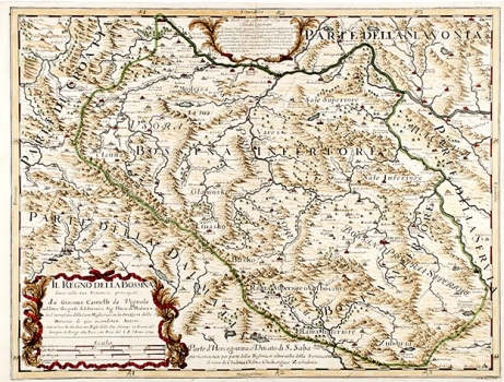
The map shows Bosnia within the boundaries, which reach north to the Sava River, to the east to the Drina River, to the west to Jajce, and to the south just above Mostar. Given that Bosnia was a part of the Ottoman Empire, the toponym is somewhat poorer than on the same map of Slavonia, but Cantelli seems to have had some data of passengers and traders, so the map contains many more names than, for example, Mercator's map. The map also includes a relatively dense hydrographic network, and the rich and credible relief is marked with shaded molehills. In the middle up, in a simple cartouche is the dedication to the prince Claudia Cogorani, and in the lower left corner, in the stylized Baroque cartouche, is the name of the map, publisher and year. In the right corner, on the edge of the print, is the name of C. C. Botzot.
CANTELLI, DA VIGNOLA GIACOMO
