CORONELLI, VINCENZO MARIA: MAP OF THE CANAL BETWEEN KORČULA AND PELJEŠAC
Inventory number 461
Author: CORONELLI, VINCENZO MARIA
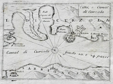
Original title: Citta e Canal di Curzola
Publishing year: 1690
Place of publishing and publisher: Venezia
Format: 12,5 x 16,5 cm
Technique: Copper engraving
The map of the Pelješac Channel was published in a small isolario "Mari, golfi, isole, spiaggie, porti, citta, fortezze, ed altri luoghi dell' Istria, Quarner, Dalmazia...", which contains numerous maps, plans and views of Croatian coastal regions. This isolario was published as a third part of the atlas "Teatro della Republica di Venezia". Large format maps included in the isolario, such as the map of Dalmatia in two parts, the map of the Zadar area, the map of the Dubrovnik Republic, etc., were folded several times and printed on thin paper. A section of Pelješac with Orebić and a part of Korčula with a faithful representation of the town with walls were portrayed using the bird's-eye view.
CORONELLI, VINCENZO MARIA
VINCENZO MARIA CORONELLI (1650-1718). He was the most famous Italian cartographer from the period of the Venetian Republic. He established the society of geographers "Accademia degli Argonauta", one of the oldest in the world. In his cartographer's workshop in Venice he gathered a number of illustrators and cartographers. The Senate of Venice supported their work with large amounts of money, and Coronelli was the first cartographer who had a reputation as an official geographer of the Venetian Republic. His maps, a part of their strategic and economical importance, were also often used as powerful instruments of exaltation of Venice and its victories over theTurks. In delineation of boundaries Coronelli usually indicates the state of things as it was before the Turkish conquests, not recognizing Turkish possessions in Dalmatia. At the same time on all his maps he noted next to various places the names of the Venetian conquests during the Morean war. In the period nearing the end of the 17th century, his maps were used by all the state services of the Venetian Republic. Coronelli was the author of the best Venetian atlases: "Isolario dell'Atlante Veneto" issued in two volumes, also named "The Great Isolario". The other is "Mari, Golfi, Isle, Spiaggie, Porti, Citta…" issued in four volumes named "The Small Isolario" that comprises over 100 port and fortress plans including as well a number of map images of the Croatian coast.
