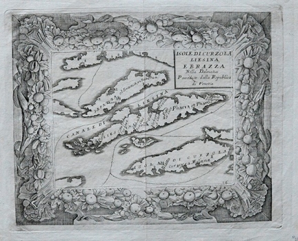
CORONELLI, VINCENZO MARIA: MAP OF THE ISLANDS KORČULA, HVAR AND BRAČ
Inventory number 418
Author: CORONELLI, VINCENZO MARIA
Original title: Isole di Curzola, Liesina e Bracca nella Dalmazia
Publishing year: 1690
Place of publishing and publisher: Venezia
Format: 20,5 x 25 cm
Technique: Copper engraving
The map of the islands of Korčula, Hvar and Brač is from the Coronelli's isolario, which was a part of the monumental "Atlante Veneto". One edition was made for the Farnese family and many views were decorated with a luxurious floral frame with two copper plates. Many of these views were published by Alessandro Locatelli in the "Racconto Historico della Veneta Guerra in Levante" in 1691 and are difficult to distinguish from Coronelli's editions.
CORONELLI, VINCENZO MARIA
VINCENZO MARIA CORONELLI (1650-1718). He was the most famous Italian cartographer from the period of the Venetian Republic. He established the society of geographers "Accademia degli Argonauta", one of the oldest in the world. In his cartographer's workshop in Venice he gathered a number of illustrators and cartographers. The Senate of Venice supported their work with large amounts of money, and Coronelli was the first cartographer who had a reputation as an official geographer of the Venetian Republic. His maps, a part of their strategic and economical importance, were also often used as powerful instruments of exaltation of Venice and its victories over theTurks. In delineation of boundaries Coronelli usually indicates the state of things as it was before the Turkish conquests, not recognizing Turkish possessions in Dalmatia. At the same time on all his maps he noted next to various places the names of the Venetian conquests during the Morean war. In the period nearing the end of the 17th century, his maps were used by all the state services of the Venetian Republic. Coronelli was the author of the best Venetian atlases: "Isolario dell'Atlante Veneto" issued in two volumes, also named "The Great Isolario". The other is "Mari, Golfi, Isle, Spiaggie, Porti, Citta…" issued in four volumes named "The Small Isolario" that comprises over 100 port and fortress plans including as well a number of map images of the Croatian coast.
