Hrvatski Deutsch English
Home Maps Authors a-e DE L' ISLE Orbis Romani Descriptio seu Divisio per Themata
DE L’ ISLE (INSULANUS), GUILLAUME: BYZANTINE EMPIRE

DE L’ ISLE (INSULANUS), GUILLAUME: BYZANTINE EMPIRE

Inventory number 395
Original title: Orbis Romani Descriptio seu Divisio per Themata
Publishing year: 1715
Place of publishing and publisher: Paris
Format: 47 x 61 cm
Technique: Copper engraving with coloured boundaries

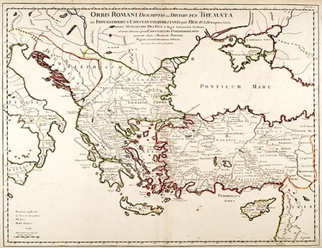
The map shows the Byzantine Empire divided into military-administrative units (themes). It was produced and published by Guillaume de L'Isle, but it was originally conceived by Anselm Bandur (Ston 1675-Paris 1743), the Benedictine of Dubrovnik, who was the curator of the Cosimo III Medici library in Florence and, as a well-known Byzantologist, he went to serve Louis XIV of France. In Paris, in 1718, he published his most famous work "Numismata Imperatorum Romanorum", which also contains one of the first extensive numismatic bibliographies. This map was very popular, and it was published in many editions of de l'Isle atlases, as well as in Covens and Mortier's atlases until 1789. It was also used with the Imperii Orientalis et Circumjacentium Regionum map in the 2nd edition of the book by French historian Charles du Fresne du Cange, "The History of Byzantine Doubles Commentario Illustratie", printed in Venice in 1729. Because that there are no traces of overlapping on the map, except in the middle, it is likely that the map originates from one of the de L'Isle's atlases, not from the du Cange's book, whose dimensions are of folio format, and the maps in it are multiple overlapped.

DE L’ ISLE (INSULANUS), GUILLAUME
DE L’ ISLE (INSULANUS), GUILLAUME (1675-1726), a French geographer and cartographer, a student of Cassini who was known as the father of modern geography. Member of L’Academie Royale des Sciences a Paris from 1702, the official royal geographer (Premier Géographe du Roy) from 1718, he began creating the World map & continents (meaning the four known continents at the time) in 1700. He made globuses and world maps, totalling to over a hundred maps and atlases. His Atlas Nouveau was published posthumously (1730), later seeing editions in other languages, too, for example Italian in the 1740s. The familiy business was succeeded by his widow with the partner Philipp Buach. His older brother JOSEPH NICOLAS L’ISLE (1688-1768) was also a student of Cassini, educated at College Mazarin. He was an astronomer and cartographer, and made a map of Russia during his service there (Sankt-Peterburg). He also founded the Academy of Science in Russia.
Print Friendly and PDF
Top