CORONELLI, VINCENZO MARIA: FRONT PAGE OF THE ISOLARIO WITH A PLAN OF TROGIR
Inventory number 394
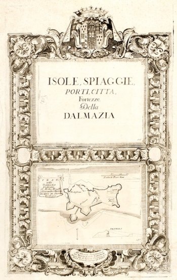
Original title: Isole, spiaggie, porti, citta, Fortezze Della Dalmazia - Trau
Publishing year: 1688
Place of publishing and publisher: Venezia
Format: 44,5 x 27 cm
Technique: Copper engraving
The upper part of the sheet decorated with rich and gorgeous border takes the title of the famous Coronelli atlas Isole, spiaggie, porti, citta, Fortezze ..., published in four volumes in 1688. It consists of more than one hundred planes of harbours and forts, and it is also called Small Isolario. The lower part of the sheet is the regional-municipal map or plan of the city of Trogir. It is depicted with a castle in the inner corner, main squares and layered city fortifications, facing the hinterland. The city plan is south-oriented, which is notable due to the replacement of the towers of St. Mark and the city castle. The simple compass arrow at the bottom edge also indicates the map orientation. the title cartouche with a dedication to Alessandro Marietta is located on the left edge of the map, and the graphic scale in the Venetian steps (Scala di Passi ven.) is featured by the upper right edge. The most key features of the city are the defensive power of city fortifications and the solid profile of the outer city walls.
CORONELLI, VINCENZO MARIA
VINCENZO MARIA CORONELLI (1650-1718). He was the most famous Italian cartographer from the period of the Venetian Republic. He established the society of geographers "Accademia degli Argonauta", one of the oldest in the world. In his cartographer's workshop in Venice he gathered a number of illustrators and cartographers. The Senate of Venice supported their work with large amounts of money, and Coronelli was the first cartographer who had a reputation as an official geographer of the Venetian Republic. His maps, a part of their strategic and economical importance, were also often used as powerful instruments of exaltation of Venice and its victories over theTurks. In delineation of boundaries Coronelli usually indicates the state of things as it was before the Turkish conquests, not recognizing Turkish possessions in Dalmatia. At the same time on all his maps he noted next to various places the names of the Venetian conquests during the Morean war. In the period nearing the end of the 17th century, his maps were used by all the state services of the Venetian Republic. Coronelli was the author of the best Venetian atlases: "Isolario dell'Atlante Veneto" issued in two volumes, also named "The Great Isolario". The other is "Mari, Golfi, Isle, Spiaggie, Porti, Citta…" issued in four volumes named "The Small Isolario" that comprises over 100 port and fortress plans including as well a number of map images of the Croatian coast.