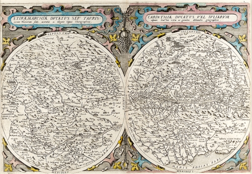
DE JODE, GERARD: STYRIA AND KRAIN
The map shows the territory of Styria and Carniola with neighboring countries in two circles in a richly decorated renaissance cartouche, which is also a frame of the maps. There is a special cartouche with a title above each circle. The towns and villages are marked by small stylized views. The map of Styria is dominated by the rivers Drava and Mura up to their mouth (Confluentes Muerae et Draus). From the countries on the side of the Drava River, the author included in the map of the Duchy of Styria the gorgeous Seeberg in the west (Kappl. mons), through Celje (Cijlij) on the Savinja River (Saana flu) to Varaždin (Warsin) in the east. Nedelijtz and Strijdo are marked in Međimurje, and the crossing over the bridge over the Drava is marked at Maribor (Marchpurg). Bridges on the Mura are at Graz (Gracz) and Bad Radkersburg (Rackelspurg). The space between Raba and Mura River north of Graz was marked as NORICI MEDITERRANEI. Hydrographic and orographic elements are recorded very schematically. The map of the Duchy of Carinola is dominated by the central view of the river Drava with the tributaries, from St. Peter in Holz (St. Peter im Holcz) in the west to Villach with the bridges (Villach) and Klagenfurt (S. Ruprecht) to Dravograd (Darburg) in the east. In the south, the map includes the area to the Trieste Bay and Aquileia (Agla Aquilea). Such chorographic maps of Austrian provinces, composed of one or more round plates without scales and limited cartographic content, were relatively common. The round shape was particularly popular with Austrian humanists. Because of the simplification and stylization of content, river flows, sea coast-lines, schematized vegetation or some other forms are hardly recognizable, especially for the marginal lands which, due to the scale, suffer the greatest distortion. Also, since the author was not interested in them, they differ most from nowadays recognizable presentations. Examples are Ducatus Carniolae by Lazuis or Ducatus Stiriae Marchiae from 1561 and Fränkische Ostmark from Austrae Chorographia by Lazius. This copy was probably published in De Jode's work Speculum Orbis Terrarum, published in Antwerp in 1578.
DE JODE, GERARD
