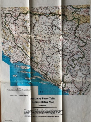
UNKNOWN: MAP TO DEFINE THE FRONTIERS OF BOSNIA AND HERCEGOVINA
The thematic map shows the territory of Bosnia and Herzegovina with a part of the eastern Adriatic coast and southern Slavonia, with border division as special content. The division of the territory of Bosnia and Herzegovina was proposed by division within the same ethnic entities using a black dotted line. The map was created during the Homeland War. It was supposed to serve as the basis for determining boundaries during the peace agreements in 1995. As stated in the map itself, it depicts demarcation within the entities, in accordance with Wright-Patterson agreement, signed in Ohio on 21 November 1995. The core content of this map are inter-entity boundaries, which are more administrative than political. The map scale is 1:600 000, and the graphic scale in miles is also drawn. Both scales are below the left lower corner of the map. A note explaining the circumstances and the reasons for producing the map and circumstances regarding its reproduction and distribution is below the map title. It was especially noted that Brčko area is still waiting for the final arbitration solution. The text says that the map followed a digital correction at the scale of 1:50 000.
ANONIM / ANONYM / NOT KNOWN
