Hrvatski Deutsch English
Home Maps Authors a-e BELLIN Carte de l' Etat Raguse et Isles Voisins
BELLIN, JACQUES NICOLAS: MAP OF THE REPUBLIC OF DUBROVNIK

BELLIN, JACQUES NICOLAS: MAP OF THE REPUBLIC OF DUBROVNIK

Inventory number 306
Original title: Carte de l' Etat Raguse et Isles Voisins
Publishing year: 1790
Place of publishing and publisher: Paris
Format: 23 x 18 cm
Technique: Partially coloured copper engraving

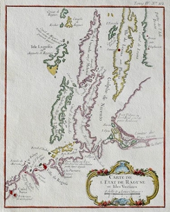
This Bellin’s map shows the Republic of Dubrovnik and surrounding Dalmatian area that at the time of this map was under Venetian rule. The map features the area comprised between the delta of the river Neretva on the north and the town of Novi (Castel Novo, today’s Herceg-Novi) on the south. Dubrovnik (Villa de Raguse), capital of the homonymous Republic identified in the centre of the coastal area shown. Being a marine chart maker, while elaborating this map Bellin was focused on the representation of bays, sea passages, ports and anchorage places. Especially prominent is the representation of the peninsula of Pelješac (Sabioncello), as an important part of the Republic of Dubrovnik. From among the southern Dalmatian islands, the islands of Mljet (Meleda) and Lastovo (Lagosta) are identified that at that time formed part of the Republic of Dubrovnik and the islands of Korčula (Cursola) and Hvar (Lesina) that were part of the Venetian Republic. At top left, a part of the island of Brača (Brasa) can be seen. The map’s title appears in the lower right corner contained in a richly decorated cartouche with engraved floral patterns. A mileage scale is expressed in French miles.

BELLIN, JACQUES NICOLAS
Bellin, Jacques Nicolas (1703-1772) was a famous French cartographer who spent many years in the French Hydrograph Service. In 1772, Bellin was appointed the first « Ingenieur Hydrographe de la Marine » (Dépôt des Cartes et Plans de la Marine), as well as later in life “Hydrograph to the King”. As the first French marine cartographer, he made many maps. He is best known for his high quality sea charts of the French colonies, including those located in North America. Bellin’s other works include atlases out of which the most noted are: «Hydrographique Francais» in 2 volumes (1756-1765) and «Petit Atlas Francais» in 5 volumes (1763), republished in 1765 under the title «Petit Atlas Maritime». He engraved world maps for Abbe Prevost’s work «Histoire Generale des Voyages (1746-1757)». For their popularity and high esteem they enjoyed, many cartographers inserted his maps in their atlases long beyond Bellin’s life span.
Print Friendly and PDF
Top