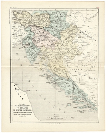
DUFOUR, ADOLPHE HYPPOLITE: MAP OF AUSTRIAN ILLYRIA
This map of the French cartographer Dufour shows the Austrian Illyria with neighbouring countries. In 1805, Napoleon conquered Istria and Dalmatia, in 1806, the Republic and Dubrovnik and in 1809 also Croatia south of the river Sava. The whole area conquered was included into Napoleon’s Illyria with Ljubljana as its capital. After the collapse of French administration in 1813, the Austrian Emperor Frantz Joseph II took possession of that area applying to it the name of “Austrian Illyria” which was made up of the following units: Carinthia, Carniola, Goritza, Istria and Croatia south of the river Sava. Besides the Austrian Illyria, the map also shows Styria and Dalmacija not making part of the Austrian Illyria and Bosnia still included in the Ottoman Empire.
DUFOUR, AUGUSTE HENRI
