UNKNOWN: DALMATIA
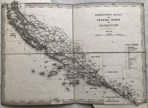
OVERVIEW SHEET: The title of the map is OVERVIEW SHEET on the special map of Dalmatia (UBERSICHTS BLATT zur special karte von Dalmatien), which, along with the numerical scale (1: 1 036 800) and the graphical scale (in Austrian miles), and the legend, is located in the upper right corner. Dalmatia is presented as the Adriatic property of the Austrian Empire, "the Austrian crown country", which was returned to Austria by the provisions of the Vienna Congress in 1815. It remained within the same boundaries not only until the the Austro-Hungarian agreement was established in 1867, but the borders would remain unchanged until the collapse of the Austro-Hungarian Monarchy in 1918. The Vienna Military Geographic Institute created this map due to the special interest of the Monarchy in Dalmatia. Topographic and astronomical-trigonometric measurements lasted for several years. Dalmatia was united in a single administrative unit, the Kingdom of Dalmatia, with its headquarters in Zadar, and divided into four districts (Zadar, Split, Dubrovnik and Kotor). Postal and political headquarters, important settlements and traffic directions are particularly represented. It is a general map with the territorial division of the Dalmatian area to 21 sheets, from northern Dalmatia in the north (Nina) to the Kotor Bay in the southeast. The political boundaries with the Ottomans, with the passages of Neum and Sutorina, were also marked. The administrative boundaries of districts are also marked. The map frame includes geographic coordinates.
ANONIM / ANONYM / NOT KNOWN
