BELLIN, JACQUES NICOLAS: MAP OF THE MOUTH OF THE RIVER NERETVA
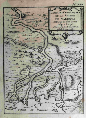
Bellin's map depicts the valley and the lower part of the Neretva River valley, as shown in the title cartouche as the Carte des Embouchures de la rivière de Narenta et de Partie de son Cours jusque a Ciclut Situeé a la Coste de Dalmatie. It is a Venetian possession before the First Austrian Government at the end of the century. The territory is in the immediate neighborhood of the Ottomans, although there is no direct indication of the enemy's presence or the proximity of the border. There are no orientation marks on the map. The French royal hydrographer Bellin emphasizeda dense hydrographic network of aquatic facilities, from rivers (R. de Narenta, R. de Narin), channels, among which he recorded especially those navigable, and marshes (Marais de Brasanich), lakes and harbours (e.g. Port pour des Galiotes) and the very mouth in the sea. He is also interested in buildings in different conditions and types, from the fortified Gabela (Ciclut), the Norin Tower (Norin) and Opuzen (Fort Opus) to the villages and ruins (Mt. Bruniach avec un Chateau ruine). The cartouche with the map title and the graphical scale expressed in miles is in the upper right corner. A note on the number of the plate in the atlas (Pl. XVIII.) is located above the map frame. Most Bellin's maps from the Felbar Collection have the same size.
BELLIN, JACQUES NICOLAS
