Hrvatski Deutsch English
Home Maps Authors a-e BELLIN Plan du Mouillage Situe ala Coste du Nord de Lìsle Melede
BELLIN, JACQUES NICOLAS: MAP OF THE NORTHERN COAST OF MLJET

BELLIN, JACQUES NICOLAS: MAP OF THE NORTHERN COAST OF MLJET

Inventory number 497
Original title: Plan du Mouillage Situe ala Coste du Nord de Lìsle Melede
Publishing year: 1771
Place of publishing and publisher: Paris
Format: 20 x 15,3 cm
Technique: Copper engraving

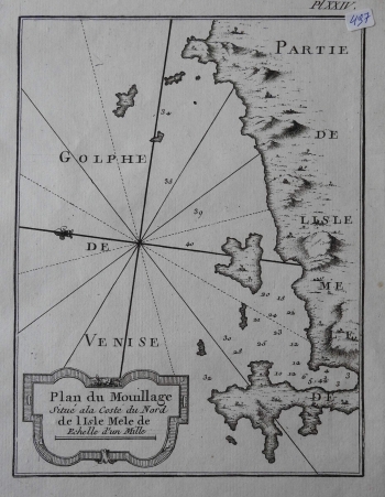
The map shows bays and anchorages on the north side of the island of Mljet which is also recorded in the title cartouche (Plan du Mouillage Situé a la Coste du Nord de Lìsle Melede). It was produced during the end of the Venetian administration or before the First Austrian Administration in Dalmatia. The map is east-oriented. The interior of the island is of secondary interest to the author and orography is only schematically depicted by scattered molehills. Toponymy of morphological forms such as coves, bays, capes and the like is completely absent. A 16-segment compass rose is located on the left edge of the map, and the lily makes it possible to determine the direction of the north. Hydrographer Bellin considered batimetric data, i.e. depths of certain sites on the north side of the island, the most interesting because they are very important for navigation. The title cartouche with the graphic scale expressed in miles (Echelle d'un Mille) is in the bottom left corner. A note on the number of the plates in the atlas (Pl. XXIV.) is located above the map frame.

BELLIN, JACQUES NICOLAS
Bellin, Jacques Nicolas (1703-1772) was a famous French cartographer who spent many years in the French Hydrograph Service. In 1772, Bellin was appointed the first « Ingenieur Hydrographe de la Marine » (Dépôt des Cartes et Plans de la Marine), as well as later in life “Hydrograph to the King”. As the first French marine cartographer, he made many maps. He is best known for his high quality sea charts of the French colonies, including those located in North America. Bellin’s other works include atlases out of which the most noted are: «Hydrographique Francais» in 2 volumes (1756-1765) and «Petit Atlas Francais» in 5 volumes (1763), republished in 1765 under the title «Petit Atlas Maritime». He engraved world maps for Abbe Prevost’s work «Histoire Generale des Voyages (1746-1757)». For their popularity and high esteem they enjoyed, many cartographers inserted his maps in their atlases long beyond Bellin’s life span.
Print Friendly and PDF
Top