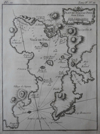
BELLIN, JACQUES NICOLAS: PLAN OF THE HARBOUR OF PULA
This Bellin's chart depicts the port of Pula. This is written in the title cartouche (Plan du Port de Pole dans l'Istrie). It was a Venetian property (Istria Veneta) before the Treaty of Campo Formio in 1797, when it came under Austrian rule. The map is east-oriented. Itp is rotated more than 90 degrees, as evidenced by the 16-segment compass rose, located at the left edge of the map. Of most interestto hydrographer Bellin were batimetric data (expressed in feet), placement of the rocks (Cape Brancorse - Galeb's rocks, Cape Compare - rt Kumpare), cliffs and rocks (Rocher de St. Catherine, Rocher de St. Pierre – in front of Agnana) and bays (Ance de Liuna - Valovine, Ance des Figuieres). The map also has many hatched hills, and along the fortified fortress of Pula, Bellin also marked the ancient amphitheater (Le Cirque ou les Arenes) outside the city walls. The title cartouche with the graphic scale is in the upper right corner. The note on the atlas (Tome IV. No. m.) is located above the map frame. This map is of a different size than other Bellin's maps in the Felbar Collection.
BELLIN, JACQUES NICOLAS
