CAMOCIO, GIOVANNI FRANCESCO: ISLAND OF HVAR
Inventory number 507
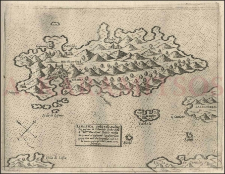
Original title: Liesena
Publishing year: 1571
Place of publishing and publisher: Venezia
Format: 16x21,3 cm
Technique: Copper engraving
This isolario shows the view of the island of Hvar (Liesena), the main Venetian port of the eastern Adriatic, from the bird's-eye view. The shape of the island is substantially altered, so that it is shortened in the east-west direction and extended in the north-south direction. Thus, the view of the deep-seated Stari Grad Bay and the more accurate location of north ports are missing. The town of Hvar (Liesena), Stari Grad (Liesna vechia), Vrboska (Barloscha) and Jelsa (Gelsa) are depicted. The port with the suburb of Hvar and the castle on the top of the hill are depicted. Military activities are not shown. The Pakleni Islands (Isole di Lisena) are located in front of the entrance to the harbour. The small island of Šćedro (Torchola) with the church of La Madonna is drawn to the south of the island of Hvar. The compass rose is on the left edge of the map. It shows that the north direction is rotated at an angle of 45 degrees in the counterclockwise direction. The atlas page is labelled as 15. The title in the cartouche located at the bottom of the map reads: LIESINA Insula nella Dalmatia patria di Demetrio locho delli S[igno]ri Illustriss[im]i Venetiani Insula riccha di terreni et bestiami Qual per longezza tien mill[ia] 60. largezza mill[ia] 25. In Venetia / apresso Gio[vann]i Franc[esc]o Camocio. The author usually signed maps he personally supplemented or corrected and judging by this poor representation of geographic forms and contours of Hvar, it is one of Camocio's most imprecise maps of the eastern Adriatic coast.
CAMOCIO, GIOVANNI FRANCESCO
CAMOCIO, GIOVANNI FRANCESCO (Camocius, Camotio, Cametti, Gioan, Joan Francisco) a Venetian cartographer, publisher and merchant whose most productive period was between 1558 and 1575. He obtained his bookseller's and publisher's licence in Venice in 1552, marked Al segno della Pyramide. His copper-plate engraving workshop produced maps and vedute that as a publisher he was signing with apresso or apud G. F. Camocio cum privilegio. The most fertile period of his artistic production, between the 1550s and the 1570s, was also the peak of the isolarii (depictions of islands) period, especially in Italy. These are detailed, practical, perspective depictions of certain cities and ports, created predominantly in a large-scale copper-plate engraving technique. Unlike earlier portulan charts, these depictions of the maritime area and the inland of the islands were largely based on field work. Along with G. Rosaccio, G. Franco and S. Pinargenti, Camocio was the most significant representative of the tradition. His interest lay on the eastern Adriatic coast where he had his informants and topographers, so he created several maps of the Croatian lands. His most famous works are Lombardija Atlantic from 1560, which he created with Forlani, Dalmatia i Friuli from 1563, Isole Famose from 1563 and 1564, Grčka, Italija i Napulj from 1566, Venecija from 1571 and Europa, published in 1579. His copper plates were passed on to Donato Bertelli. Copper plates were, at the time, passed on, inherited, exchanged and traded, and the information they carried was also often exchanged among cartographers and publishers. His most famous maps of our (Croatian) territories are Novo dissegno della Dalmatia et Crovatia from 1566, Istra from 1569, and he also authored the isolario or atlas Isole famose, porti, fortezze e terre maritimme… from 1571 and 1574, comprising a large number of maps of the Croatian territories, although he did not author all of the maps contained within it. Almost twenty of his maps are depictions of the Croatian Littoral or port vedute, but he only signed some of them, which are most likely the ones he personally refined or updated. His maps of Dalmatia and Istria show that he had access to higher quality topographic templates or data only for some regions, such as Coppo’s map of Istria from 1525. He also published the works by local cartographers, Natalo Bonifaci and Martino Rota, from where he clearly sourced the cartographic information for his own works. He was obviously very skilled in selecting the information he would use, as he tried to correct some frequently repeated errors he had come accross.