CAMOCIO, GIOVANNI FRANCESCO: KORČULA
Inventory number 508
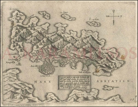
Original title: Curzola
Publishing year: 1571
Place of publishing and publisher: Venezia
Format: 15,6 x20,3 cm
Technique: Copper engraving
This isolario is in fact a panoramic map of the island of Korčula viewed from the bird's-eye view. The compas rose in the uper right corner shows that the north is bottom. The shape and outline of the island are hardly recognizable. The peninsula on which the city of Korčula is located is disproportionately bigger than the island. This allows the entire city to be displayed in a half-view and partially stylized. The town of Korčula is fortified by ramparts and towers, and the town can be accessed from three sides. The main entrance to the city (Porta della citta) is in the east. Rows of houses are located along the access road to the south city gate, above the city ramparts. Vineyards and gardens of the citizens of Korčula are displayed in the hinterland of the city. The vineyards occupy the entire northern side of the island, while the interior of the island is rich in forests. Orography is indicated by schematic molehills. City shipyards (Squeri) are marked in two ports of the town of Korčula, on the east and west sides. The La Madonna church is at the bottom of the west harbour. Coastal islets have Italian names (Bobarda, Fornase, Forcha and others). A part of the Pelješac peninsula (Sabioncello) is visible at the bottom of the map. The map name and description of the miraculous defence of the city from Ottomans are in the square-shaped cartouche: Curciola insula et citta nella Dalmatia delli Ill[ustrissi]mi Ven[etia]ni ultim[ament]e assalita da gran parte d’la arm[at]a Turchescha, qual citta quatuq[ue], bene munita di ogni presidio fusse, fu timidam[ent]e dalli homini abbadonata, et dalle donne miraculosam[ent]e diffesa con offesione di nemici. 1571. In Venecia / apreso Gio[vann]i Franc[esc]o Cam[ocio]. Co[n] priuilegio. The author usually signed maps he personally supplemented and corrected, as is the case with this map. The isolario page is labelled as 17.
CAMOCIO, GIOVANNI FRANCESCO
CAMOCIO, GIOVANNI FRANCESCO (Camocius, Camotio, Cametti, Gioan, Joan Francisco) a Venetian cartographer, publisher and merchant whose most productive period was between 1558 and 1575. He obtained his bookseller's and publisher's licence in Venice in 1552, marked Al segno della Pyramide. His copper-plate engraving workshop produced maps and vedute that as a publisher he was signing with apresso or apud G. F. Camocio cum privilegio. The most fertile period of his artistic production, between the 1550s and the 1570s, was also the peak of the isolarii (depictions of islands) period, especially in Italy. These are detailed, practical, perspective depictions of certain cities and ports, created predominantly in a large-scale copper-plate engraving technique. Unlike earlier portulan charts, these depictions of the maritime area and the inland of the islands were largely based on field work. Along with G. Rosaccio, G. Franco and S. Pinargenti, Camocio was the most significant representative of the tradition. His interest lay on the eastern Adriatic coast where he had his informants and topographers, so he created several maps of the Croatian lands. His most famous works are Lombardija Atlantic from 1560, which he created with Forlani, Dalmatia i Friuli from 1563, Isole Famose from 1563 and 1564, Grčka, Italija i Napulj from 1566, Venecija from 1571 and Europa, published in 1579. His copper plates were passed on to Donato Bertelli. Copper plates were, at the time, passed on, inherited, exchanged and traded, and the information they carried was also often exchanged among cartographers and publishers. His most famous maps of our (Croatian) territories are Novo dissegno della Dalmatia et Crovatia from 1566, Istra from 1569, and he also authored the isolario or atlas Isole famose, porti, fortezze e terre maritimme… from 1571 and 1574, comprising a large number of maps of the Croatian territories, although he did not author all of the maps contained within it. Almost twenty of his maps are depictions of the Croatian Littoral or port vedute, but he only signed some of them, which are most likely the ones he personally refined or updated. His maps of Dalmatia and Istria show that he had access to higher quality topographic templates or data only for some regions, such as Coppo’s map of Istria from 1525. He also published the works by local cartographers, Natalo Bonifaci and Martino Rota, from where he clearly sourced the cartographic information for his own works. He was obviously very skilled in selecting the information he would use, as he tried to correct some frequently repeated errors he had come accross.