CAMOCIO, GIOVANNI FRANCESCO: SPLIT
Inventory number 509
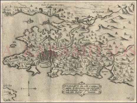
Original title: Spallato
Publishing year: 1571
Place of publishing and publisher: Venezia
Format: 15,3 x 20,4 cm
Technique: Copper engraving
This panoramic map represents a part of Middle Dalmatia with the hinterland, i.e. the large surrounding area of Split. It is also a somewhat stylized panoramic view of Split. The western part of the Kaštela coast with the fortress of Grisogono, Kaštel Sućurac (C. della badessa), Kaštel Gomilica (C.o Archivescovo), Solin bay, Marjan and the coast to Žrnovnica (Zarnounizza) and saltworks in the area (Saline) are depicted. Well-groomed gardens and orchards and access roads from various sides are found in the city hinterland which is rare in such old maps. The west side of the port is surrounded by a rampart that descends to the sea. The bell tower of the church of St. Domnius (Sv. Dujam) can be discerned, although the outline of Diocletian's palace is unrecognizable in relation to other houses. There are several churches in the surroundings: S. Stefano, S. Zorzi, Betelem, S. Micheli, Madona di paludi, s. Pietro, S. Catarina, S. Lorenzo and others. Camocio was among the first to note that there are remains of the ancient Salona (Ruine di Salona Citta antiqua) in the north along the coast of Kaštela. Vranjic (Vragnica) is marked in the Bay of Solin. The Jadro River (Fiume di Salona) with mills is in the hinterland. The old fort of Gradina (Cast.o a turchi ruin.o) was restored by the Venetians. The compass rose is in the left lower corner indicating that the north is on the top of map. The classic Renaissance cartouche with the title of the map is at the bottom edge. The following data are recorded: Spallato citta nobile et antiqua patria di Diochlisiano imperatore posta nella Dalmatia sopra il mare Adriatico loco delli Ill[ustrissi]mi S[igno] ri Venetiani. The atlas page label (12) is in the lower right corner. The quality of the displayed geographic information points to inferior mapping information and skill in relation to, for example, Rota's works on the Trogir and Split environs.
CAMOCIO, GIOVANNI FRANCESCO
CAMOCIO, GIOVANNI FRANCESCO (Camocius, Camotio, Cametti, Gioan, Joan Francisco) a Venetian cartographer, publisher and merchant whose most productive period was between 1558 and 1575. He obtained his bookseller's and publisher's licence in Venice in 1552, marked Al segno della Pyramide. His copper-plate engraving workshop produced maps and vedute that as a publisher he was signing with apresso or apud G. F. Camocio cum privilegio. The most fertile period of his artistic production, between the 1550s and the 1570s, was also the peak of the isolarii (depictions of islands) period, especially in Italy. These are detailed, practical, perspective depictions of certain cities and ports, created predominantly in a large-scale copper-plate engraving technique. Unlike earlier portulan charts, these depictions of the maritime area and the inland of the islands were largely based on field work. Along with G. Rosaccio, G. Franco and S. Pinargenti, Camocio was the most significant representative of the tradition. His interest lay on the eastern Adriatic coast where he had his informants and topographers, so he created several maps of the Croatian lands. His most famous works are Lombardija Atlantic from 1560, which he created with Forlani, Dalmatia i Friuli from 1563, Isole Famose from 1563 and 1564, Grčka, Italija i Napulj from 1566, Venecija from 1571 and Europa, published in 1579. His copper plates were passed on to Donato Bertelli. Copper plates were, at the time, passed on, inherited, exchanged and traded, and the information they carried was also often exchanged among cartographers and publishers. His most famous maps of our (Croatian) territories are Novo dissegno della Dalmatia et Crovatia from 1566, Istra from 1569, and he also authored the isolario or atlas Isole famose, porti, fortezze e terre maritimme… from 1571 and 1574, comprising a large number of maps of the Croatian territories, although he did not author all of the maps contained within it. Almost twenty of his maps are depictions of the Croatian Littoral or port vedute, but he only signed some of them, which are most likely the ones he personally refined or updated. His maps of Dalmatia and Istria show that he had access to higher quality topographic templates or data only for some regions, such as Coppo’s map of Istria from 1525. He also published the works by local cartographers, Natalo Bonifaci and Martino Rota, from where he clearly sourced the cartographic information for his own works. He was obviously very skilled in selecting the information he would use, as he tried to correct some frequently repeated errors he had come accross.