BELLIN, JACQUES NICOLAS: MAP OF THE NORTH ADRIATIC
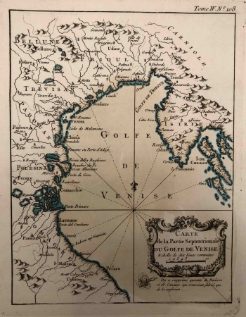
The chart shows the northernmost part of the Adriatic Gulf (Golfe de Venise), the River Po and the Friuli in the west, across the Trieste Bay to the Istrian peninsula in the east. As indicated in the title, Bellin emphasized the western part of the northern Adriatic, and, unlike the other charts by this French hydrographer, the interior on this chart is almost as detailed as the coastline. The dynamics of the coastal relief are marked by shading and even by concatenated molehills in the interior. A 16-segment compass cross is in front of the Ravenne harbour. North is on the top of the chart. There are no common notes of sea depths or anchors on this chart. Interestingly, in the view of the Kvarner Islands, apart from Krk (Veglia), the island of Cres (I. de Cherso) in the northern part is labelled with the present-day name, while the entire southern part of the island is labelled with the name Osor (Osero). The name Osor is adapted from ancient times, when it referred to the entire archipelago (Apsyrtides). The French hydrographer recorded the entire island of Lošinj as I. Osero. Only Veli Lošinj, as the southernmost settlement, is labelled with a new name (Losin). The title cartouche with the graphic scale (Echelle de dix lieues communes) is in the bottom right corner. An explanation of the reduction of hydrographic inventory for better legibility of the chart (On a supprimé quantité de Rivières et des Canaux qui n'auroient fait de la confusion) is below the cartouche. Despite generalizing the content by excluding rivers in the drawing, the author still recorded them with toponyms, limnonyms (Bocca dela Bagliona) and potamonyms (Bouches du Po et ses Alluvions), both in the Po lowlands and on the coast. Volume Tome IV. No 108 was recorded above the upper edge of the chart.
BELLIN, JACQUES NICOLAS
