LASOR A VAREA, ALPHONSUS: ISTRIAN PENINSULA
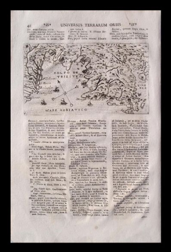
This is a copper-plate cartographic map by Raffaello Savonarola, who took the pseudonym which was a rewrite of his own name, and in its focus are the Venetian lagoons and the Gulf of Trieste. It also shows the entire Istrian Peninsula with its hinterland and even a part of the Kvarner Bay in the east. The coastlines are quite unconvincing and imprecise, as is the hydrographic network. The boundary lines of Venetian and Austrian possessions are not indicated. At the far end of the Adriatic Gulf a simple compass rose is drawn, along with illustrations of several sailing ships. This map is part of the single book sheet on page 46, and at the top of the sheet is the name of the atlas Universus Terrarum Orbis Scriptorum Calamo Delienatus, published in 1713. The author included templates of the best Italian cartographers and engravers such as, in this case, Camocio in 1571 (map from the Felbar Collection inv. no. 546) or Giuseppe Rosaccio (map from the Felbar Collection inv. no. 240) and its editor Giacomo Franco, who in 1598 in Venice created this map for the atlas Viaggo da Venetia a Constantinopoli per mare e per tere et insieme di Terra Santa. This means that Savonarola had Coppo's and Bertelli's data at his disposal, and like Camocio, he also placed a compass rose on his map and used small vedute to emphasize and single out Italian towns on the western facade of the peninsula. In spite of all this, almost two centuries after recording the recent data on this map, the relief is still schematized by molehills and quite unreliable, and the hydrographic network is overstated and in some parts arbitrary, so it seems that the Padovian did not use reliable sources.
A VAREA, LASOR
