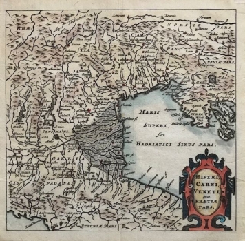
BERTIUS, PETRUS; CLUVER, PHILIP: MAP OF CARNIOLA WITH ITS NEIGHBOURING COUNTRIES
This miniature map shows the territory of Carniola with its neighbouring countries on the northern Adriatic coast (Maris Superi, gray Hadriatici Sinus Pars), among which is the name of the ancient Rhaetia. The map was part of the pocket atlas entitled Introductionis in Universam Geographiam tam Veterem quam novam, made collaboratively by the theologian, historian and cartographer Petrus Bertius and the German historian and geographer Philip Cluver. Toponymy, and especially horonyms, from Etruria and Cispadana in the Apennine Peninsula to Pannonia and Histria on the eastern Adriatic coast date back to ancient times. And while orography is schematized by molehills and hydrography is also compressed, the authors specifically indicate the importance of the Po Valley. In the lower right corner is a richly decorated Renaissance title cartouche. The contours of Istria and the contours of the Kvarner Islands are only roughly sketched, with a basic hydrographic network and data on the population in the mountainous hinterland of the eastern Adriatic coast (Iapydes). Most of the more recent topographic data, already known to the Italian cartographers at the time, were omitted by Fleming.
BERTIUS, PETRUS
