LASOR A VAREA, ALPHONSUS : VEDUTE OF SPLIT AND ENVIRONMENT
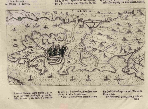
This copper-plate map by Raffaello Savonarola shows Split, highlighted by a slightly more pronounced veduta on the cartographic representation of the wider surroundings, or deeper hinterland. In the foreground is a long breakwater. In the fortified city there are visible symbols such as medieval walls and the gate embedded in the defensive fabric of the newly built part of the city, and the prominent bell tower of the Split Cathedral of the Assumption of the Blessed Virgin Mary, better known by the name of the patron saint of St. Domnius. Roads and fields are visible in the city's hinterland, and eight sailing ships are sailing in the marine environment. Both the relief and the coastline are simplified and almost unrecognizably compressed, both in relation to the 1558 Rota’s map of the same area, and especially to Camocio's 1571 veduta representing an almost identical area that was made using the same technique (inv. no. 509 ). In the area of Salona, several symbols for larger and smaller remains of the ancient ruins (Kastela Bay) are inscribed, and they are also referenced in the text below the map. Particularly noticeable on the map is the Klis Fortress at the intersection of several traffic routes. Several very useful forts of the time can be seen in the hinterland. Žrnovnica is drawn in the eastern (Stobreč) port and below it there is a simple compass rose. This map is part of the single book sheet on page 524, and at the top of the sheet is the name of the atlas Universus Terrarum Orbis Scriptorum Calamo Delienatus, published in 1713. Although he did not have access to better originals, Savonarola took over other authors’ templates that he was familiar with, as evidenced by the fact that the same copper-plate engraving was published much earlier by Giuseppe Rosaccio (see no. 250) in his work Viaggo da Venetia a Constantinopoli per mare e per tere et insieme di Terra Santa, published in Venice in 1606.
A VAREA, LASOR
