MAP OF ISTRIA
Inventory number 546
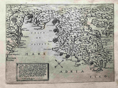
Original title: Istria sotto il dominio Veneto
Publishing year: 1571
Place of publishing and publisher: Venezia
Format: 20,7 x 15,5 cm
Technique: Copper engraving
A simple square cartouche of this Istrian map, with the author's signature and the date, is located in the lower left corner. Camocio most probably used a map of Istria by Pietro Coppo from Del sito de l'Istria, published in 1540, as a template when creating the map. Camocio published this copy in Isole famose... and it was published in both his editions, 1571 and 1574. A simple compass rose is placed south of the peninsula, with an arrow pointing north. In the title cartouche the author emphasizes the dense population and natural resources due to the favourable position of Istria (molte Citta, Castelli, Villas, fonti, fiumi ... Isole, porti), as well as the abundance of olive oil, wine, grain and fruit that the peninsula provides. He engraved the towns in individualized outlines, but the urban fabric was composed of schematized religious and secular architecture. He particularly emphasized to him the more important and larger Italian towns from the western Istrian coast. The relief display is somewhat overstated and simplified by the molehill scheme. Relief dynamics are absent from the depiction, especially on the example of Učka. With an exaggerated hydrographic content and toponym selection, this map is quite reminiscent of the maps of Istria by his associates Donato and Ferrando Bertelli, or the Pinargenti map from 1573. Although Camocio places Rijeka on the eastern coast of Istria, judging by the takeover of some newer toponyms, especially compared to his three years older large map of Istria, this map paves the way for correcting old templates with newer topographic data.
CAMOCIO, GIOVANNI FRANCESCO
CAMOCIO, GIOVANNI FRANCESCO (Camocius, Camotio, Cametti, Gioan, Joan Francisco) a Venetian cartographer, publisher and merchant whose most productive period was between 1558 and 1575. He obtained his bookseller's and publisher's licence in Venice in 1552, marked Al segno della Pyramide. His copper-plate engraving workshop produced maps and vedute that as a publisher he was signing with apresso or apud G. F. Camocio cum privilegio. The most fertile period of his artistic production, between the 1550s and the 1570s, was also the peak of the isolarii (depictions of islands) period, especially in Italy. These are detailed, practical, perspective depictions of certain cities and ports, created predominantly in a large-scale copper-plate engraving technique. Unlike earlier portulan charts, these depictions of the maritime area and the inland of the islands were largely based on field work. Along with G. Rosaccio, G. Franco and S. Pinargenti, Camocio was the most significant representative of the tradition. His interest lay on the eastern Adriatic coast where he had his informants and topographers, so he created several maps of the Croatian lands. His most famous works are Lombardija Atlantic from 1560, which he created with Forlani, Dalmatia i Friuli from 1563, Isole Famose from 1563 and 1564, Grčka, Italija i Napulj from 1566, Venecija from 1571 and Europa, published in 1579. His copper plates were passed on to Donato Bertelli. Copper plates were, at the time, passed on, inherited, exchanged and traded, and the information they carried was also often exchanged among cartographers and publishers. His most famous maps of our (Croatian) territories are Novo dissegno della Dalmatia et Crovatia from 1566, Istra from 1569, and he also authored the isolario or atlas Isole famose, porti, fortezze e terre maritimme… from 1571 and 1574, comprising a large number of maps of the Croatian territories, although he did not author all of the maps contained within it. Almost twenty of his maps are depictions of the Croatian Littoral or port vedute, but he only signed some of them, which are most likely the ones he personally refined or updated. His maps of Dalmatia and Istria show that he had access to higher quality topographic templates or data only for some regions, such as Coppo’s map of Istria from 1525. He also published the works by local cartographers, Natalo Bonifaci and Martino Rota, from where he clearly sourced the cartographic information for his own works. He was obviously very skilled in selecting the information he would use, as he tried to correct some frequently repeated errors he had come accross.