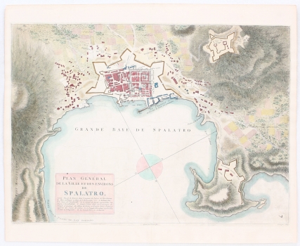
PLAN OF THE PORT OF SPLIT
This larger-scale plan is comparable to the half-century-older plan of the port of Split and its water area by Joseph Roux (inv. no. 503). In contrast to the bathymetric data on Roux’ plan, this one is dominated by the specific shading of the accentuated relief achieved by hatching, above all on the eastern and western sides of the city, towards Marjan. In the bottom right corner is the page numbering (7). Along the bottom edge of the map are the names of Perrier’s descendants signed as engravers, and the map itself was drawn by Dien. The author built on Mortier, Santini and Coronelli's templates, with richer architectural content within the walls. In the title cartouche, in the lower left corner, there is a key of the numerical location markers on the map. In the port is a simple compass rose with four segments. Like Roux, Cassas marked the fortifications in the floor plan and explicitly stated that the ramparts were built during the Kandyan Wars. In addition to the marked Diocletian’s Palace (Palais de Diocletien), there is a modern fortification tower on the southeast side of the defensive wall. In the port are the lazzarettos, and the text next to them explains how the quarantine was organized inside them, and for whom such measures were prescribed. The Gripe Fortress (Le fort de la Gripe) in the hinterland is also marked, as well as the destroyed fortifications on the Boticelle peninsula (Bačvice). Split is connected with different road routes to its deeper interior. The map was most likely published in the Voyage Pittoresque et Historique de l'Istrie et de la Dalmatie, which Cassas published together with Lavallee.
CASSAS, LOUS FRANCOIS
