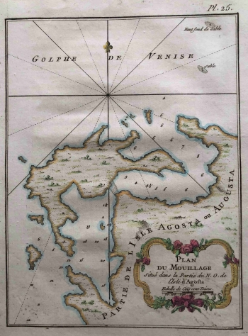
MAP OF THE ISLAND OF LASTOVO WITH ANCHORAGES IN FRONT OF THE PORT
The map shows the sheltered northwestern Lastovo Port of Pasadur with substantial information about the depth of the sea and the anchorages in the bay. The Island of Vlašnik, both Islands of Maslovnjak (Mali and Veli) and the Makarac islet are pronounced. It is interesting that the French hydrograph also recorded the shallows, marked as sandbanks, especially the one towards the Prežba islet. The engraving is slightly and inconspicuously coloured, especially the floral cartouche frame in the lower right corner. In addition to the title, it contains a graphical scale measured in a unit of 500 fathoms (Toises). Along the upper edge, towards the open Adriatic is a wind rose, divided into 16 segments, with a lily symbol indicating that the north is located along the upper edge of the map. There are no marked settlements, and the relief is highlighted by the shading of mounds or molehills. In the northeast corner of the map, towards the open sea (Golphe de Venise), several sandbanks are indicated as potentially hazardous navigable sites. Above the top edge of the map is the plate mark P. 25. In terms of style and content, the map is part of Bellin's maps of the Croatian coast, kept in the Felbar Collection, and even in terms of dimension it corresponds to similar items (inv. no. 533, 495, 496, 497, 498).
BELLIN, JACQUES NICOLAS
