VIEW OF ROVINJ AND OSOR
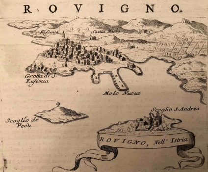
The panoramic veduta of Rovinj is on the list of isolarios measuring 34.5 x 44 cm (Small isolario). The author described the distance from the nearest towns, its historical names, the location of the port and the security of the ships in a text in Italian language at the bottom and around the map. Then he provided information on buildings such as churches, and population. The town of recognizable sight, which was often reproduced on the maps of its predecessors, is located on a peninsular elevation, protected by a wall facing the open sea and sheltered by the islands from the south, among which is St. Andrew (Red Island). There is a waterfront with three queys (Molo Nuovo) in the southern port. In addition to the church of the same name, which dominates the silhouette of the town on the west side of the peninsula, the caves of the same name (Grotta di S. Eufemia) are also depicted. Several other small churches in the hinterland are marked, including Santa Maria. Of interest are the fenced and probably cultivated gardens in the hinterland of the town and in the garden of the islet monastery. In the bottom right corner of the map is the title cartouche. Rosaccio published a similar map of Rovinj in his atlas Viaggio da Venetia… back in 1598.
The isolario, or a panoramic view of the fortified Osor, is, like the map of Rovinj, on the list of the isolaria measuring 34.5 x 44 cm, on page 142. Below the map there is also a description of the history of the town, the changing of its names (Apsyrtides), notes on the church history of the town, population, architecture, churches and even the economy, all in the Italian language. The map itself shows Osor, viewed from across the bridge, from the southwest, Lošinj side. The Island of Lošinj the author calls by an alternative name (Isola d'Osero), and isolated houses and cultivated and enclosed agricultural lands are marked on the island. Osorčica is outlined on the western edge, although it is located more to the east, on the central ridge of the island, parallel to the edge of the island. Representative ecclesial architectural entities, such as churches and bell towers, like the low wide tower adjacent to the main church, are recognizable in the very view of the city. The monumental facade and barrel-shaped vaulting of the impressive cathedral stand out in particular. In addition to the town churches, there are also isolated churches, such as the one named S. Marie, inscribed also in the deeper town hinterland (Isola di Cherso). The sacred structures were also the most visible from the sea, and extremely important for the terrestrial navigation. The town walls overlooking the bridge side and the Osor canal are also visiblw. The Osor bridge itself is narrower in the central part, so it can be assumed that it is partly mobile or prefabricated.
CORONELLI, VINCENZO MARIA
