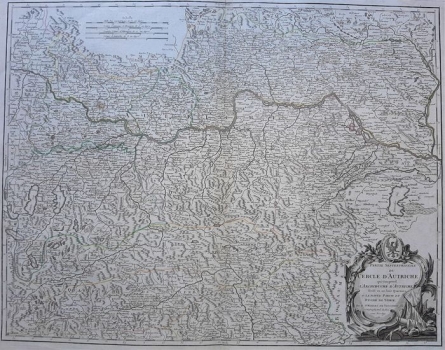
MAP OF THE NORTHERN COUNTRIES OF THE AUSTRIAN EMPIRE
The map shows in great detail and with a dense network data the countries of northern Austria as divided by Charles V, including the area from Radstadt to Bratislava. The cartographic content is very rich, from topographic (vegetation and orography made in profile) to political information. It refers to a part of the Habsburg hereditary lands (Upper and Lower Austria, Styria, part of Carinthia) before the Napoleonic Wars, with the seat of the House of Habsburg or the Holy Roman Emperor in Vienna. The title of the map is in the lower right corner in a richly decorated Baroque cartouche, with heraldic insignia and a reminder of the recent war on the eastern borders (military weapons and flags). Below the upper edge there are multiple graphic scales. This map was published in 1757 by Atlas Universal, which included maps made on the basis of field work, so this map is very accurate in relation to its contemporary ones, although with some inaccurate or omitted historical terms. There are no Croatian countries on the map.
DE VAUGONDY, DIDIER ROBERT
