MAP OF THE AUSTRIAN COUNTRIES
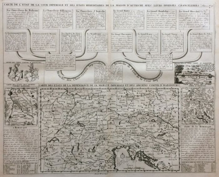
On the map domus Austriae (Austrian house, although the countries ruled by the Habsburg family did not have a unique name, but that of the Habsburg Monarchy became common) the Dutch publisher shows the countries ruled by the dynasty. The map itself is located at the bottom of the sheet from the second volume of the Atlas Historique, published by Chatelain in 1720 in Amsterdam. The title is at the top of the list and refers to the textual chapters with an explanation of the offices of the constituent countries of the Habsburg Monarchy on the outskirts of the Holy Roman Empire of the German nationality, regardless whether these estates are inside or outside the Empire. The map below the textual descriptions of the countries involved has a separate title Carte des Stats de la Dependance de sa Maieste Imperiale et des Anciens Comtes d'Habsbourg, which interprets the political relationship of the countries shown with the House of Habsburg. The main map is equipped with a geographic network and a graphical scale. In this way, the French cartographer demonstrates a combination of good information about the administrative and legal structure of the Empire on the one hand and his own graphic-cartographic skill at the peak of the French era of cartographic domination on the other. The borders between the provinces, such as Upper Austria (Autriche) or Carniola (Carniolle), Carinthia (Carinthia), Styria (Stirie) or Croatia (Croatia) or Slavonia (Slavonia) are not highlighted nor is the specific status of any of them specifically indicated. Some of them are possibly divided into lower and upper. It is especially interesting traditional provinces are recorded by the superimposition of the geographical names, while for example the eastern borders of the Empire, i.e. the information on the recent change of borders on the Sava and Una Rivers in accordance with the Karlovac or Požarevac Peace Treaty was not recorded. The basic map is surrounded by three auxiliary maps of the Habsburg lands and graphics of the family coat of arms. Apart from toponyms, primarily chorons, which are also in the thematic focus of this map and the names of the settlements themselves and the simplified presentation of the river network, the rest of the cartographic content is reduced to schematized elements of vegetation.
CHATELAIN, HENRI ABRAHAM
