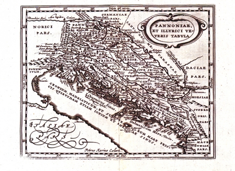
CLUVERIUS, PHILIPP: MAP OF PANNONIA AND ILLYRICUM
Inventory number 76
Author: CLUVERIUS, PHILIPP
Original title: Pannonia et Illyrici veteris tabula
Publishing year: 1629
Place of publishing and publisher: Amsterdam
Format: 15,5 x 20 cm
Technique: Copper engraving
This is another redesign of Ortelius' historical map of the Roman Illyricum and Pannonia (ref. catalogue No. 42). A Dutch cartographer Philippe Cluverius (1580-1622) issued it. The map was published in his "Introductio in Universam Geographicam" in 1629.
CLUVERIUS, PHILIPP
CLUVERIUS, PHILIPP (PHILIPPE CLUVERIO, (1580-1622 ili 1623), from Granjsk, who worked as a geographer in Leiden. He specialised in the topics from the Middle Eastern and Classical Antiquity geography. Some of his most notable works are Foederatae Rhetiae descriptio from 1600, Geographicus Academicus, published in Leyden in 1616, Intro in Universam Geographicam from 1629, Rhaetia, published by Visscher in 1630, and Germaniae antiquae libri from 1631.
