Hrvatski Deutsch English
Home Maps Authors f-j HONDIUS JODOCUS Histria
HONDIUS, JODOCUS: MAP OF ISTRIA

HONDIUS, JODOCUS: MAP OF ISTRIA

Inventory number 201
Original title: Histria
Publishing year: 1627
Place of publishing and publisher: Leiden, Bonad & Abraham Elzevir
Format: 18,5 x 24,8 cm
Technique: Coloured copper engraving

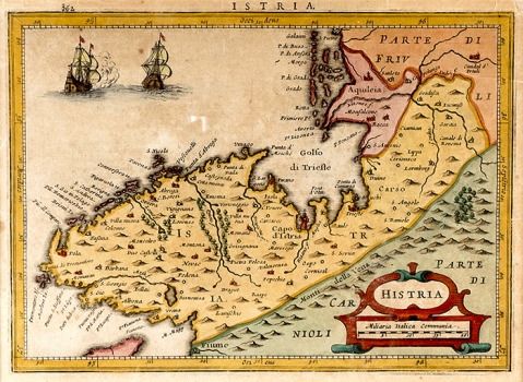
This map of Istria was included in the second issue of Hondius' work “Nova et accurata Italiae Hodiernae descriptio”, printed in Leidenu by publishers Bonad and Abrahama Elzevir in Leiden in 1627. This map was reduced from the map of Istria made by Antoni Mangini in 1620. What appears to be unusual in this Hondius’ edition is that the whole map is orientated with west. The map shows all of Istria with the Bay of Trieste. The topography is shown schematically with individually drawn molehills. Compared to the original by Magini, the number of settlements is reduced in accordance with the map’s relatively small size. The reduced geographic content is however largely compensated by the map’s exceptionally attractive graphic design. The title is in the lower right corner featured within a late-Renaissance cartouche. The scale is given in Italian miles (Miliaria Italica communia).

HONDIUS, JODOCUS
After Ortelius' death, JOCODUS HONDIUS (1563-1611) continued his work. Hondius was a graphic artist and map publisher. He spent ten years in London where he was producing globe models. Around 1593/94 he went back to Amsterdam. In 1604 he bought Mercator's engraving plates, and in 1606 he finished his work on the first enlarged edition of the Atlas of Mercator to which he added 36 new maps. Until 1611 he published five more editions of this atlas (In 1607 the atlas was edited in Latin and in French, in 1608 in French and in 1611 in Latin). HENRICUS HONDIUS (1587-1637) succeded Jacodus Hondius and continued to publish Mercator-Hondius atlases.
Print Friendly and PDF
Top