HOEFNAGEL, GEORG: VIEW OF POREČ
Inventory number 88
Author: HOEFNAGEL, GEORG
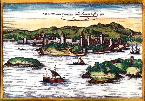
Original title: Parens Siue Parentium vulgo Parenzo Histrie opp./ George Hoefnagel
Publishing year: 1576
Place of publishing and publisher: Köln
Format: 17 x 24 cm
Technique: Coloured copper engraving
This map was based on the previously existing map image of Poreč published by Bernard von Breydenbach (approx. 1440-1497) in his work "Opusculum sanctarum Peregrinationum in terram Sanctam" of 1486. The map shows Poreč seen from the sea. The island of Sveti Nikola with its Benedictine monastery built in 1404 is shown in the foreground. The town itself is represented within the system of defense walls with a number of towers and turrets. Inside the walls the basilica of Euphrasius and St. Mary's church with the adjacent monastery are clearly seen. This copper etching in hand coloring is one of the finest Renaissance map images of Poreč. The title is placed along the inner margin edge.
HOEFNAGEL, GEORG
HOEFNAGEL, GEORG [JORIS] (1542-1600), a Belgian painter and topographer. Travelling around the world, he created over 100 vedute for the work Civitates Orbis Terrarum. This monumental work in six volumes was published by Georg Braun (1541-1622), a German topographer and geographer, and the famous Frans [Francius] Hogenberg (1535-1590), a Flemish artist and copper-plate engraver who engraved maps for the famous Ortelius’s atlas entitled Theatrum Orbis Terrarum. In the period from 1573 to 1590, together with Georg Braun he published several editions of Civitates Orbis Terrarum, which was entitled Theatrum nobiliu oppidorum orbis terrarum, Colonia Agr. 1576 in its edition from 1576.
